The Import Google Earth File command allows you to insert a KML (Keyhole Markup Language or alternatively a KMZ) file of points (KML Placemark), polylines (KML Path) and closed polylines (KML Polygon) into your drawing. Throughout this discussion, KML will be used to also describe KMZ files unless explicitly noted.
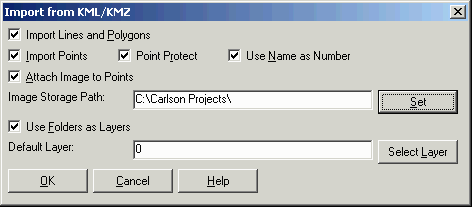
Import Lines and Polygons: When this option is selected, KML Path and Polygon entries will be placed into the drawing as open or closed polylines, respectively.
Import Points: When this option is selected, KML Placemark entries will be placed into the drawing and active coordinate file.
Point Protect: When enabled, existing points in the active coordinate
file will not be over-written.
Attach Image To Points: This option
applies to KML files created by SurvCE when the points are stored
together with an image. This option to attach the image to the
point symbol. The images can be viewed using the Image/Document
Inspector command. The image files are extracted from the KML and
stored in the specified folder set in Image Storage
Path.
Use Folders as Layers: When enabled, KML Folder entries will be used to create layer names in CAD and the supported KML options described above will be placed onto the layer that conforms the the Folder to which they belong.
Default Layer: The supported KML options described above that are not contained in a KML folder will be placed into the specified layer.
Google Earth File to Read: Select a previously saved KML or KMZ file.
Pulldown Menu Location:
File > LandXML/RoadXML/Google
Earth
Keyboard Command: kmlread
Prerequisite: A KML or KMZ file with Placemark, Path and/or
Polygon information, an active coordinate file with an established
projection zone through Drawing
Setup.