In addition to providing a graphical method for displaying feature-rich data located anywhere on the globe, Google Earth also provides the ability for software applications to extract its aerial imagery. While the positional accuracy of the Google Earth surface should be considered "approximate," it might be suitable for preliminary land-planning studies or "proof-of-concept" preliminary designs.
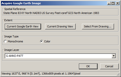
Consider the following example. Based on the physical screen size of the Google Earth application and the "zoom" (or "view") resolution of a project site, the following values (summarized at the bottom of the dialog box) were returned:
| Unit | Horizontal | Vertical |
|---|---|---|
| Feet | 1637 | 966 |
| Pixels | 1366 | 809 |
| Feet/Pixel | 1.19 | 1.19 |
In the sample above, the total area is calculated and displayed (0.1 mi2) along with the desired "spatial reference" coordinate system for our project site.
Spatial Reference: Displays the spatial reference coordinate projection system of the current drawing. The projection can be set using the Drawing Setup command.
Extent - Current Google Earth View: Gets the overall dimensions of the Google Earth session and displays the results in both pixels and the appropriate units of measure.
Extent - Current Drawing View: Gets the overall dimensions of the current CAD view and displays the results in both pixels and the appropriate units of measure.
Extent - Select from Drawing: Sets the overall dimensions of the Google Earth session to conform with a drawing window from CAD and displays the results in both pixels and the appropriate units of measure.
Image Type: Allows the ability to indicate the type of image to be placed into the drawing. Gray-scale images can be inserted into the drawing automatically, color drawings must be manually saved from Google Earth and then selected for insertion in the CAD drawing (see the Prompts section below).
Image Layer: Allows the ability to indicate the layer upon which the image should be inserted.
First corner/Identify Entity <Current view>: Identify one corner of a drawing window that should be used to set the Google Earth display or pick an existing entity with discreet upper and lower bounds to define a region or press Enter to use the current view (this is the same as the "Extent - Current Drawing View" option above).
Specify opposite corner: Identify the opposite corner of a drawing window that should be used to set the Google Earth display.
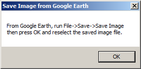 For Color images: Use Windows
functionality (Alt+Tab) to switch focus to the Google Earth
application and use the Google Earth > File > Save > Save
Image command (Ctrl+Alt+S) to save the current Google Earth
image. Once saved,
For Color images: Use Windows
functionality (Alt+Tab) to switch focus to the Google Earth
application and use the Google Earth > File > Save > Save
Image command (Ctrl+Alt+S) to save the current Google Earth
image. Once saved,
Click OK on the Carlson alert dialog box
shown above and locate/select the image just saved. Click Open when
the file has been located
Pulldown Menu Location:
Images
Keyboard Command: google_image
Prerequisite: Coordinate projection system, Functioning
version of Google Earth, Internet connection