ESRI ArcGIS Services
The ESRI_ArcGIS_Services
command provides access to existing ESRI image files.
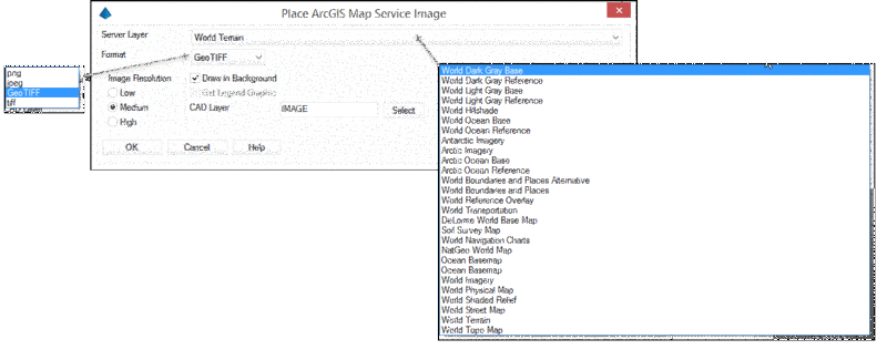
Server Layer:
Contains a list of available image files from
the ESRI library
Format Type: Select the image format
type from:
Image Resolution: Sets the resolution for the image as low,
medium or high. The resolution may depend on the image selected,
display settings and hardware.
Draw in Background: When enabled, sets the draw order to
place the image in the background.
Get Legend Graphic: When available, draws a legend
graphic.
CAD Layer: Sets the layer for the image file to placed in
the drawing.
After selecting the server layer, click OK and the data will
be imported.
Prompts
Pick first corner of bounding
box: Indicate one corner of a
rectangular box that identifies your area of interest.
Pick second corner of bounding box:
Indicate the other corner of a rectangular
box that identifies your area of interest.
Image File to Save: Create a name for the image file that will be
imported.
See Also:
- To import other Web Based Layers into your drawing, use the
Web Feature Service (WFS)
command.
- To import Web Map Service images into your drawing, use the
Place Web Map Service (WMS) Image command.
Pulldown Menu Location(s): GIS Data
Keyboard Command: eagmsExport
Prerequisite: Internet connection, Coordinate System
Projection set through Drawing
Setup