The Import LandXML File routine provides a mechanism where land-based data from other software applications (including Carlson Software) can be brought into a project and used for analysis and/or design purposes. To import a LandXML file, a series of dialog boxes are presented:
Select LandXML File: Specify the name of a LandXML file you wish to import.
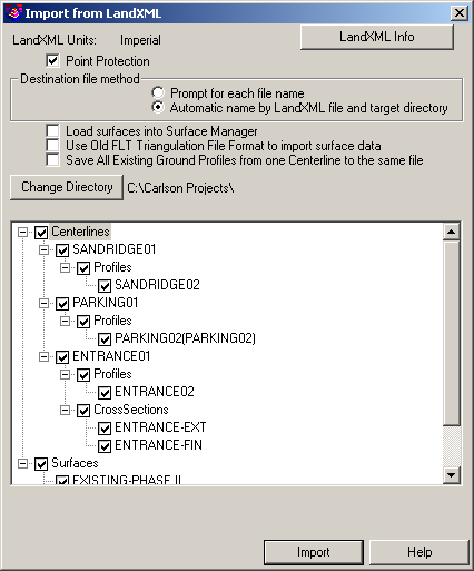
LandXML Units: Indicates the Units of Measure associated with the incoming LandXML file (see the Unit Differences item below).
Point Protection: When enabled, you are prompted for a course of action if an existing LandXML file you've selected contains COGO points that have the same number(s) as those that already exist in the drawing. When disabled, existing point data in the project is updated with the values from the LandXML file.
Destination File Method: This option allows you to indicate how the incoming data file(s) are named as they are imported.
Load Surfaces into Surface Manager: When enabled, this option will automatically add surface model (TIN) data into the Surface Manager and graphically represents (draws) the surface model/contours according to the current settings found in the Triangulate & Contour command.
Use Old FLT Triangulation File Format to Import Surface Data: When enabled, the older ASCII-based Carlson *.FLT file format will be used in place of the newer and more efficient *.TIN file format.
Save All Existing Ground Profiles from One Centerline to the Same File: When enabled, collections of existing ground profiles associated with a particular centerline are combined into a single *.PRO file.
Change Directory: This option allows you to adjust the folder location where the new data files will be written.
Import from LandXML: Enable or disable various entries that should used to produce the data files found within the LandXML file.
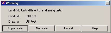
Unit Differences: If the Units of Measure specified in the LandXML file are different than those found in Drawing Setup, you will be prompted for a course of action.
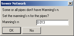
Manning's "n": If you are importing sewer data from a LandXML file and if the LandXML file does not carry Manning's "n" values, you will be prompted to specify a default Manning's "n" value for all incoming sewer entities that don't already have a Mannings "n" value.

Import Structures: If you are importing sewer data from a LandXML file and
structure values specified in the LandXML file do not exist in the
Structure Library, you will be prompted to indicate the
structure(s) that should be imported into the Structure Library.
Use standard Windows click, shift+click and/or
ctrl+click functionality to select multiple structures at
the same time.
Skip
Invisible Triangles: This option applies to importing TIN
surfaces from Civil 3D. When this option is active, triangles
marked by Civil 3D as invisible or excluded are not
imported.
Pulldown Menu Location(s):
File > LandXML
Keyboard Command: landxml_import
Prerequisite: A LandXML file to import