This command allows you to tag Carlson points in the drawing so
that they will not be used when creating a surface. These
could be points that are far from the site, such as off-site
horizontal control, or points with elevations that are not on the
ground, such as a TBM taken on the top of a fire hydrant.
There are several methods available to select the points for
tagging as non-surface points. One key to remember is that
they must be present in the drawing to be tagged.
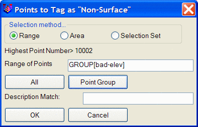
Range: This option
allows you to specify a range of point numbers, or select ALL of
the points currently in the drawing, or specify a Point Group,
remembering, however, that only points that are currently in the
drawing can be tagged. So if you select a Point Group, but
only some of the points listed in the Point Group are currently
present in the drawing, the whole Point Group will not be
tagged
Area: This option
allows you to utilize inclusion and/or exclusion polyline(s) to
specify an area in the drawing within which any points currently in
the drawing are tagged as non-surface points.
Selection Set:
This option allows the manual selection of points within the
drawing.
Description Match:
This option allows the filtering of selected points by
descriptions. For example, you could use a Range of ALL, but
set the Description Match to TBM, and only the points with that
description would be tagged.
Pulldown Menu Location: 3D Data >> Non-Surface Points
Keyboard Command: tagns
Prerequisite: Carlson points in a drawing
| Converted from CHM to HTML with chm2web Standard 2.85 (unicode) |