Elevate Pads by Grade Rules
This command sets the elevation of closed polylines at a
specified slope from reference 3D polylines. For each closed
polyline, the program finds the nearest offset to a reference
polyline. Then the pad polyline is elevated using the reference
polyline elevation at this nearest offset position and applying the
vertical offset as the slope times the offset distance.
When the original pad polyline is 3D, the program maintains the
original slopes of the 3D polyline and elevates by raising or
lowering the 3D polyline instead of setting all the vertices to the
same elevation. This method applies for a pad with varying
elevations such as for an exposed basement.

The Reference Elevation
has four methods. Elevation At Middle uses the middle position of
the pad polyline segment that is on the frontage side of the pad
and locates the station along the reference polyline that is at the
perpendicular offset from this position. Highest Elevation takes
the frontage segment of the pad polyline and checks the station
range for this segment along the reference polyline to find the
highest elevation within this range which is used as the elevation
reference. Likewise, Lowest Elevation uses the lowest elevation on
the reference polyline in front of the pad. The Reference Point
method uses a point placed along the pad by the Tag Pad Reference
Point command.
The program prompts for the existing surface triangulation file
which is used to compare to the reference elevation and choose
between using the specified cut or fill slope from the reference
elevation to the pad. This feature allows you to have steeper
slopes in cut than fill conditions to help with site
balancing.
The Min and Max Slopes are stored with the pad
polylines for use by the site balancing option in Calculate Total
Volumes in SiteNet. These slopes are used as grading rules to make
sure the pad stays within this slope range from the reference
polyline when the pads are raised or lowered during the site
balancing. The Min and Max Slopes are not used during the Elevate
Pads By Grade Rules which only uses the Cut/Fill Normal slopes. Use the Grade
Rules Editor command to edit these slopes and elevation reference
info that is assigned to the pad polyline.
The Vertical Offset is added to the elevations of the pad
polylines.
The Assign New Layer
option changes the original layer to the specified layer for the
elevated pad polylines. The Retain
Original Polyline option creates new elevated polylines and
leaves the original polylines unmodified.
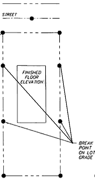
The Add Grade Breaks to Reference Polylines adds break
points to the side lot lines at the ends of the building pad as
shown in this graphic.
 The Draw
Swale Polyline creates 3D breakline polylines to control storm
water flow around the building pad. When the lot is sloping towards
the street, the swale polyline is at the back of the pad as shown
in the left graphic. When the lot is sloping away from the street,
the swale polyline is at the front of the pad as shown in the right
graphic. The swale polyline elevation is set relative to the
building pad elevation by the Slope From Pad, and the
Cross Slope controls the swale elevations for connecting
with the lot sides. The Offset From Pad sets the distance
from the building pad to the swale polylnie. The Center
Taper controls how much the swale polyline bulges out in the
middle and the Edge Extend sets the position of the swale
polyline break points from the side lot lines.
The Draw
Swale Polyline creates 3D breakline polylines to control storm
water flow around the building pad. When the lot is sloping towards
the street, the swale polyline is at the back of the pad as shown
in the left graphic. When the lot is sloping away from the street,
the swale polyline is at the front of the pad as shown in the right
graphic. The swale polyline elevation is set relative to the
building pad elevation by the Slope From Pad, and the
Cross Slope controls the swale elevations for connecting
with the lot sides. The Offset From Pad sets the distance
from the building pad to the swale polylnie. The Center
Taper controls how much the swale polyline bulges out in the
middle and the Edge Extend sets the position of the swale
polyline break points from the side lot lines.

Prompts
Select Existing Ground
Surface Pick the existing triangulation surface
Select reference elevation
polylines.
Select objects:
select reference 3D polyline with
elevations
Select pad polylines to
elevate.
Select objects:
select pad polylines to
elevate
Loading edges...
Loaded 826 points and 2250
edges
Created 1425
triangles
Elevated 4 pad
polylines.
Pulldown Menu Location: 3D Data >> Elevate By Grade
Rules
Keyboard Command: elevate_pads
Prerequisite: 3D reference grade line, closed polyline pads
to elevate
