Resource/Reserve Classification
The Resource/Reserve Classification command provides a report
based on the area of each zone. The tonnage associated with each
zone (Measured, Indicated, Inferred, and Hypothetical) can then be
calculated using the Surface Mine
Reserves command (found in either the Geology or Surface Mining
module). The four classification zones have traditionally been
based off of the following distances from a drillhole, but you can
modify these distances to your liking.
- Measured: x < 1320 ft (1/4 mile)
- Indicated: 1320 ft < x < 3960 ft (1/4 mile to 3/4
mile)
- Inferred: 3960 ft < x < 15840 ft (3/4 mile to 3
miles)
- Hypothetical: x > 15840 (3 miles)
The first prompt is to create a new, or select an existing Reserve
Classification file *.RSV.
The next step is to define a strata name to search for in the
drillholes selected along with the quality name and name of the
grid file to use. The program processes each line in the list,
taking into account only drillholes which have strata specified and
calculating from the grid quality values for each zone. The command
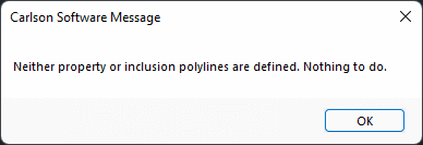
uses property lines, or at the least, an inclusion polyline, to
define the extent of the area of reserve. Nothing will be
calculated if there is no property line or standard inclusion
perimeter selected, and the following error will appear.
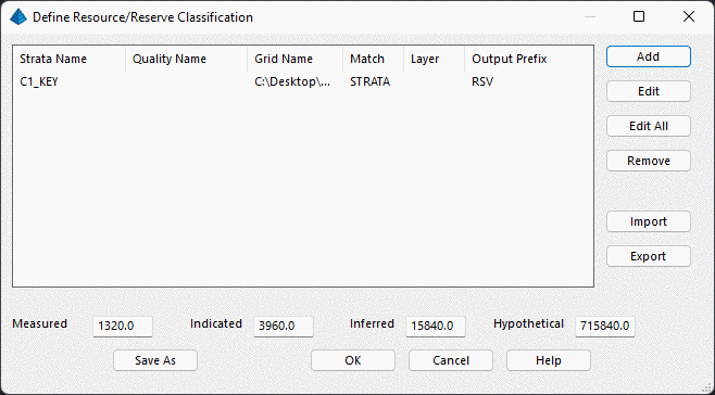
After selecting drillholes and a boundary line,
the below dialog will appear. Here you can add a new strata layer
to analyze with the
Add button.
When adding a new strata to the list, the below dialog will
appear.
- Strata: This sets the
name of the strata to analyze. Note that this must perfectly match
the strata/bed name in the drillhole. When using bed names, it is
important to include the Bed Name and the grouping suffix. For
example, the above example shows the name that must be entered for
the Key portion of the C1 bed (C1_KEY).
- Quality: This is the
quality attribute to analyze, such as thickness, BTU, etc. It is
not required to enter a value for this field.
- Grid: This is the grid
name that has been created from the drillholes. It will compare
these modeled values with the occurrences and spacing in the
drilling.
- Match Both Strata and
Quality: This will make sure that the quality and strata
name both are defined in a drillhole. If just the strata name is
there, but no quality sample, then it will not be used as a sample
point that is measured.
- Inc/Excl Layer: These
are the layers that the perimeters are drawn in.
- Result Layer Prefix:
This is a prefix it will put in front of the output layer names.
The program will create layer names such as "_A_MEASURED" and
"_B_INDICATED". If the prefix is set to "RSV", then the resulting
layers would be "RSV_A_MEASURED" and "RSV_B_INDICATED".
- Draw Polylines: This
will draw the perimeter polylines that contain the hatching for the
four classifications.
- Draw Hatch: This will
draw the hatching inside the perimeters and boundaries of
classifications.
- Skip Report: This
option just does the CAD graphics and mapping only, not generating
the report.
- Assign Pit Names: This
option will give a Pit Name to each perimeter, so it may be used
for other volume calculations with commands such as Surface Mine
Reserves.
- Save Cut Set: This option will create a named cut set
for the boundaries, which may be used with Surface Mine Reserves or
the Timing commands to further divide volumes/tonnage into relevant
categories. Note that when using Surface Mine Reserves or the
Timing commands, you must enable the options to report by Property
Boundaries to also use the cut set.
The results are shown as colored maps layerized by the chosen
quality, with color changing based on the corresponding reserve
class.
The report is show below using the Ascii Text report option:
Reserve
Classification
Wed Jun 04 15:40:18 2014
Owner
Harvey
Property
BR549
Strata
name
WK6_KEY
Quality
Thickness
Quality
Grid
C:\2012 UG\Reserve Classification\WK6_KEY_THK.GRD
Average Value
2.9
Total Area (sq.ft) 28953106.4
Measured Area (sq.ft) 12898291.2
Measured Acres
296.1
Measured Value
2.731
Indicated Area (sq.ft) 16054819.9
Indicated Acres 368.6
Inferred Area (sq.ft) 0.0
Inferred Acres
0.0
Hypoth. Area (sq.ft) 0.0
Hypoth. Acres
0.0
Indicated Value 2.974
Owner
LLoyd
Property
ABC
Strata
name
WK6_KEY
Quality
Thickness
Quality
Grid
C:\2012 UG\Reserve Classification\WK6_KEY_THK.GRD
Average Value
2.6
Total Area (sq.ft) 3850616.2
Measured Area (sq.ft) 3850616.2
Measured Acres
88.4
Measured Value
2.628
Indicated Area (sq.ft) 0.0
Indicated Acres 0.0
Inferred Area (sq.ft) 0.0
Inferred Acres
0.0
Hypoth. Area (sq.ft) 0.0
Hypoth. Acres
0.0
Indicated Value
Prompts
Select Reserve File dialog
Reserve Classification dialog
Select Drillholes to process: select drillholes to use in
calculations
Select Inclusion polyline:
Report Formatter Dialog
Pulldown Menu Location: StrataCalc
Keyboard Command: reserve_class