This command creates a polyline file that contains the point data of the select polylines. The objects supported by this tool include polylines, arcs and lines. If you want to include text, you must use the Text Explode To Polylines command found in the Edit menu to convert the text to polylines before running this command. Several different output formats are supported.
The Carlson format (.PLN) is a text file format that is used by some Carlson commands and by machine control (Carlson Grade, Dozer 2000, GradeStar) for the plan view. Each polyline begins with a line of "POLYLINE, Color number, etc". Then the points for the polyline are listed on separate lines in X,Y,Z format.
The DTM and Idan formats create linework files for the DTM and
Idan programs.
The KOF method creates a .KOF format file.
The MicroStation format (.txt) can be imported into MicroStation. This format has the coordinates as space delimited for each polyline point. There is an extra column with a 1 or 0 where 1 specifies the start of a new polyline.
The Moss format creates a INP file for the MXROAD/MOSS Genio program.
The Peabody format is a company specific format for Peabody Energy.
The Topcon format creates a Topcon LN3 file.
Polyline file format [<Carlson>/DTM/Idan/MicroStation/MOSS/Peabody/Topcon]? Specify the desired output option by specifying the CAPITALIZED option or press Enter for the <default> option.
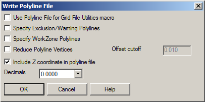
Polyline File to Write dialog: Create a new file or Append to Existing. If the Carlson option was selected, the following dialog then appears:
Use Polyline File for Grid File Utilities macro: When enabled, the option will write a polyline file that can be used with Grid File Utilities for inclusion/exclusion perimeters.
Specify Exclusion/Warning Polylines: When enabled, this option applies to machine control for warning areas.
Specify WorkZone Polylines: When enabled, this option applies to machine control for working areas.
Reduce Polyline Vertices: When enabled, this option applies the Reduce Polyline Vertices to the polyline vertices before writing the file..
Offset Cutoff: Indicate the allowable offset distance (essentially the middle ordinate distance of a 3-point arc) that would allow the middle vertex between two other vertex locations to be removed.
Include Z coordinate in polyline file: When enabled, this option controls whether the elevation(s) (or "Z" value) of the selected polyline vertices are written to the polyline file.
Decimals: Indicate the desired amount of precision for the coordinate values that should be written to the file.
Select polylines, lines and arcs to
write.
FILter/<Select entities>: Pick
the entities to process press Enter when
complete.
POLYLINE,51,0,0.0,CONT|V-STRM-PIPE
5375168.9320,3932304.7050,0.0000
5375193.3310,3932211.6150,0.0000
POLYLINE,150,0,0.0,CONT|V-BRKL
5375026.8800,3932090.0480,962.8334
5375062.3960,3932105.7540,961.5399
5375075.5640,3932115.7940,961.1595
5375079.0150,3932128.0920,961.1532
5375081.6860,3932159.7840,961.6147
5375086.6920,3932195.6480,962.6206
etc.
Pulldown Menu Location: File > Export
Keyboard Command: polywrite
Prerequisite: Polylines in the drawing
| Converted from CHM to HTML with chm2web Standard 2.85 (unicode) |