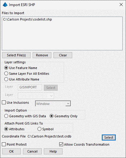
The import function allow one or more SHP to import at
once. The Select File(s) can selected more than one
file. This command converts ESRI SHP files into Carlson
drawing entities and can also optionally write the available
attribute data to an external data source which was defined in GIS
Database settings. There are two Import Options, Geometry
with GIS Data or Geometry only. If the Geometry with GIS
Data is selected, then the GIS Data will be imported.
Otherwise, if Geometry only is selected, then only the entities
will be drawn .
It is required to specify layer name which the entities will be
created. There are three options for the layer name, Use
Feature Name, Same Layer For All Entities, and Use Attribute
Name. If the Same Layer For All Entities is selected, then it
is required to enter the Layer Name. If the Use Attribute
Name is selected, then it is required to pick a attribute name from
the feature's attribute list. This option is only available
if there is only one Shapefile selected.
There are primarily three types of ESRI SHP files: Points, Arcs
and Polygons. Each will provide different options on
Import.
If there is a points SHP in the file list, then the user has the
option to setup Attach Point GIS Links to either Attributes or
Symbol. Also the user can select Point
Protect. Point SHP files are imported in a three step
process. The first step uses the Import SHP File command to
create a coordinate file (.crd/.crdb) for the points in the SHP
file and a corresponding table in the the points database. The
second is to use Draw Locate Points to draw the points from the CRD/CRDB
file into the drawing. The third step uses Create Links to select
the points in the drawing and link the database to these plotted
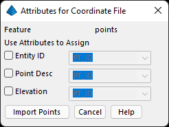
points. Currently, we only allow you to configure
attributes for the coordinate file if there is only single that
file needs to be imported.

Note: If the SHP file you are
Importing is in a different Projection or Units than that specified
in the Drawing Setup, then a transformation will occur during
Import, as long as the (.PRJ) Projection file is present with the
SHP set of files. If there is no (.PRJ) file with the SHP,
then no transformations will occur.

Pulldown Menu Location: GIS Data
Keyboard Command:
import_shp
| Converted from CHM to HTML with chm2web Standard 2.85 (unicode) |