File Menu: Export
3.11 Coordinate File
FUNCTION: The Export > Coordinate File routine is used to create and save a file of coordinate points in a non-ASCII format. Available formats include: Carlson Numeric (the default format); Carlson Alpha-numeric; C&G Numeric; C&G Alpha-numeric; Simplicity "Sight" Survey 3 files; and Land Desktop Development files.
Activate the Export > Coordinate File routine by picking from the File: Export menu; or by pressing [Alt][F], [E], [C].
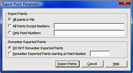
Export
Points: Click the radio button (![]() )
on any one of the three options. You may export All Points in the
File; export All Points Except (specified) Numbers; or export
Only Point Numbers specified.
If you select either options two or three, in the corresponding field you must
enter the subject point numbers using the Rules for Defined Figures and Point
Strings as found in
Section 6.20.
)
on any one of the three options. You may export All Points in the
File; export All Points Except (specified) Numbers; or export
Only Point Numbers specified.
If you select either options two or three, in the corresponding field you must
enter the subject point numbers using the Rules for Defined Figures and Point
Strings as found in
Section 6.20.
Renumber Exported Points: There may be times when you wish to renumber the exported points so they will not conflict with points in another file should they be later imported into that file. If that is the case, select the option to Renumber Exported Points starting at Point Number and enter the new starting point number into the adjacent text entry field.
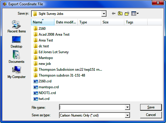
[Export Points]: Click this button to select or specify the export data file name.
Use the standard Windows dialog box to select a folder location, or to create a new folder. Left-click on an existing file to select that file to be overwritten, or type in a new name into the File name field. Also choose a file type using the Save as type field. When you have completed your selections, click [Save] and return to the previous dialog box to set your export parameters.
|
|
CAUTION: Always remember - if you specify an existing file name, that file WILL be overwritten with new data. |
File Name: Enter a filename into this field or select an existing file name. Click [Save] to export the coordinate file.
Save as Type: Click [q] to select the coordinate file type (format) to write.