Contour Elevation Label
This command can be used to simultaneously create elevation
labels on a group of contour polylines at elevation. First the
command starts with a dialog with the label options. Then to place
the labels, pick two points crossing the contour polylines at the
desired label location. The program will find all the contour
polylines that intersect the picked line (defined by the two picked
points) and will place labels at the intersection point of each
contour. A second crossing line can be initiated immediately, so
multiple areas can be quickly labeled while remaining in the
command. Alternatively, you can type P for Polyline at the Command
prompt and select a polyline. Then the program finds all the
intersections between the selected polyline and the contours and
places labels at these intersections. The actual "z" elevation of
the contour line determines the label value.
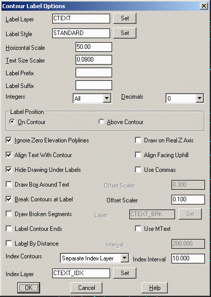
Label Layer specifies
layer name for the contour labels that will be
created.
Label Style specifies the text style to be used for
labels.
Horizontal Scale is used in conjunction with the Text Size
Scaler to determine unit height of the contour labels.
Text Size Scaler is a scaler that will be multiplied by the
horizontal scale to set the actual text height of the labels in
AutoCAD units.
Integers controls how many digits to label to the left of
the decimal. For example, if all contours are in the 5000's, then
setting for three digits would label the 5280 contour as
280.
Decimals sets the decimal precision for the labels to be
created.
Label Position determines the label position in relation to
the contour polyline.
- On Contour centers the
label on the contour line.
- Above Contour places
the label above the contour line. If this option is used, the
options for Break Contours at Label and Draw Broken Segments become
inactive.
Ignore Zero Elevation
Polylines enables the routine to filter out all entities
with an elevation of zero.
Hide Drawing Under Labels activates a text wipeout feature that
will create the appearance of trimmed segments at the contour
label, even though the contour line is still fully intact. This
feature provides the user with the best of both worlds; you have
clean looking contour labels, yet the contour lines themselves
remain contiguous. This feature will also hide other entities that
are in the immediate vicinity of the contour label.
Align Facing Uphill makes
the label parallel to the contour and flips the label so that it
reads facing uphill. Otherwise, the labels are made to face up
relative to the current screen view. When this option is on, the
program prompts for a triangulation surface file that should match
the surface the contours represent.
Use Commas adds a comma into the labels for the thousands
place such as "5,000" instead of "5000".
When Align Text with Contour is checked, contour elevation
labels will be rotated to align with their respective contour
lines.
When Break Contours at Label is checked, the contour lines
will be broken and trimmed at the label location for label
visibility.
When Draw Broken Segments is checked, segments of contours
that are broken out for label visibility will be redrawn as
independent segments. Specify the layer for these broken segments
in the box to the right of this toggle.
Label Contour Ends creates labels off the ends of the
contours.
Label By Distance places the labels by distance along the
contour. The user is not prompted for screen picks of contour
crossing when this option is used.
- Interval sets the
distance interval to be used between labels on each
contour.
When Draw Box Around Text is checked, a rectangle will be
drawn around the elevation labels. The Offset Scaler controls the
size of the rectangle.
The Draw On Real Z Axis
chooses between creating the text entities at the elevations of the
contours or at zero elevation.
The Use MText chooses
between creating MText and DText label entities.
Index Contours: Label All will label both index and
intermediate contours with the same settings. Label Index Only
labels only the index contours. Separate Index Layer will label
both index and intermediate contours with the index labels on a
different layer.
Prompts
Contour Label Options Dialog Opens Select the
desired options and press OK.
Define a line which slices the contours at the desired label
locations.
Pick 1st point (P-Polyline, Enter to end): pick a
point
Pick 2nd point: pick a point
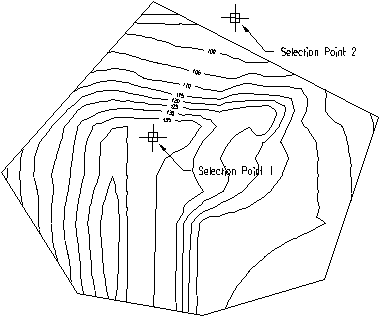 By selecting two points the contour lines that cross the
line defined by the two points are labeled.
By selecting two points the contour lines that cross the
line defined by the two points are labeled.
Pulldown Menu Location: Surface >> Contour Labels
Keyboard Command: gclabel
Prerequisite: polylines with elevation (contour
polylines)