Snap Contours to 3D Polylines
Snap Contours to 3D Polylines can be used to align contour
polylines to match elevation with intersecting of a 3D polylines.
Doing so will fix spikes in a surface model. The program will ask
for the Contours to be adjusted. Pick will allow you to grab the
contours from the plain view, Select allows you to identify the
layer(s) from a list. The layers under Contour Layers will be
adjusted to match the Reference Layers at the point of
intersection. A Reference layer can be identified by Pick or Select
as well.
The Maximum Snap Distance is the furthest distance along the
Reference line the Contour polyline will move in order to match
elevations. Z Tolerance sets the minimum elevation difference
between the Reference line and the Contour polyline for the program
to process. Anything less than this number will not be modified.
Transition Distance is the length over which the positioning change
will be applied to the Contour polylines.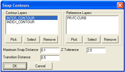 After
selecting OK, you will be prompted for the entities to process.
Pick or Window Select the linework you want to process. You can
also type in "all" to select everything. Here is a standard report
that is displayed on the command line:
After
selecting OK, you will be prompted for the entities to process.
Pick or Window Select the linework you want to process. You can
also type in "all" to select everything. Here is a standard report
that is displayed on the command line:
Entities in set: 282
Select entities:
Contour polylines: 125 Processed, 12 Adjusted
Pulldown Menu Location: Elevate (in Takeoff), 3D Data (in
Civil)
Prerequisite: 3D linework
Keyboard Command: snap_cntrs