This command contains several functions for deed (.PDD) files. A deed file consists of one or more deed descriptions. Each deed description includes a deed name, starting coordinate and line/curve data. This deed data can be created with the Enter Deed Description command. This command begins with the Process Deed File dialog.
Edit Opens the Edit Deed dialog where you can view or
modify the deed name, starting coordinates, or line/curve data.
Within this dialog the following commands are available.
Add Opens the Edit Deed dialog where you can add a new
deed.
Remove Removes the currently highlighted deed.
Draw Draws the currently highlighted deed in the drawing
and returns to the main dialog. The actual geometry will not appear
in the drawing until you exit Process Deed File. There is an
option to label the deed using the settings from the Annotate
Defaults and Auto-Annotate commands.
Report Generates a report for the currently highlighted
deed. The report is displayed in the Standard Report Viewer unless
Use Report Formatter is active which allows for customized reports
and Excel output using the Report Formatter. For the Report
Closure, the Start-End Coordinates option uses the difference
between the POB (point of beginning) and the coordinates of the
last call to calculate the closure error. The Angle-Distance
Precision option determines the closure error by starting with the
POB and calculating each point in the deed using the angle and
distance values entered. Distance values are further affected by
the precision in the report settings.
Copy Creates a new deed by copying the geometry of the
highlighted deed.
Export Saves the selected deed data (.PDD) in raw file
format (.RW5) that can be used with Edit-Process Raw File.
Save Saves the currently loaded deed (.PDD) file.
SaveAs Allows you to save the currently loaded deed
(.PDD) file to another file name.

List Selects the starting coordinate from a point
selection list from the current coordinate file.
Pick Allows you to screen pick the starting
coordinate.
Order Allows you to set the sequence of the columns in
the spreadsheet editor.
Add Allows you to add a new deed call (line or
curve).
Remove Removes the highlighted deed call.
Move Up/Down Change the list order of the data records
for the currently highlighted row.
Angle Mode Choose between Azimuth or Bearing
inputs.
Angle Format Choose between using one spreadsheet cell
for the angle in dd.mmss format or using three cells with dd, mm
and ss in separate cells for easier editing.
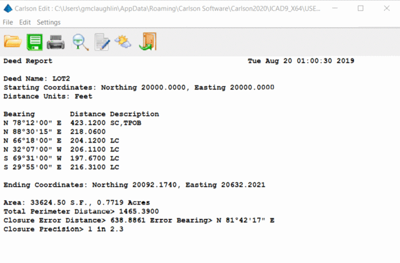
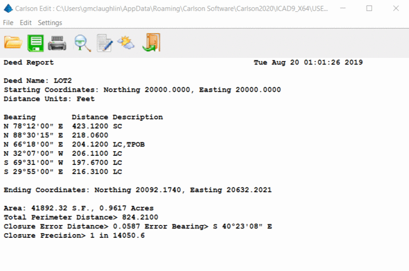
The POB location is variable on the deed. This means when
entering or editing a deed, you may select any call in the deed to
be the POB (Point of Beginning). The total perimeter, closure error
and precision are determined from this point to the last call of
the deed. Other calls leading up to the POB may be included in the
deed as reference or commencement calls but not used in the closure
calculations.