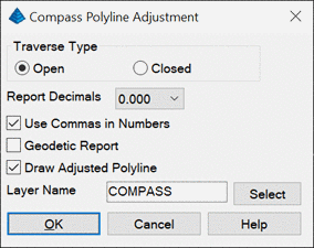
Compass Polyline Adjustment
This command applies a compass adjustment to a perimeter defined
by a polyline. After selecting the polyline, the program displays
arrows to show the polyline direction and you have an option to
reverse the polyline. The command draws a new polyline of the
adjusted perimeter and creates a report. The closure error is the
difference between the end point of the polyline and the specified
closing point that the program prompts for. In the dialog, you can
set the Traverse Type as Open or Closed. For a closed loop
adjustment, the closing point is the starting point of the
polyline. For an open traverse, the program will prompt for the
closing point.
For the Geodetic Report option, the program reports the geodetic
distances and angles. To use this option, the grid projection must
be define in Settings > Drawing Setup.
Here is an example report for a closed loop.
Compass Polyline Adjustment
Closure Results
Starting Point : N 4854.766 E 5357.221
Ending Point : N 4854.636 E 5357.533
New Point : N 4854.766 E
5357.221
Azimuth Of Error : N 67°22'29" W
North Error : 0.130
East Error : -0.312
Distance Error : 0.338
Distance Traverse: 1029.503
Closure Precision: 1 in 3050
Original Data
From
To
Angle
Distance
4
5
S 13°01'45" E 392.218
5
11 N
44°23'59" E 296.297
11
N 60°02'20" W 340.987
Adjusted Point Comparison
Original
Adjusted
Point#
Northing Easting
Northing Easting
Dist Angle
4
4854.766 5357.221
4854.766 5357.221 0.000 N
90°00'00" E
5
4472.645 5445.645
4472.695 5445.526 0.129 N
67°22'29" W
11
4684.343 5652.952
4684.430 5652.744 0.226 N
67°22'29" W
4854.636 5357.533
4854.766 5357.221 0.338 N
67°22'29" W
Adjusted Data
From
To
Angle
Distance
4
5
S 13°00'50" E 392.143
5
11 N
44°22'56" E 296.261
11
N 60°02'29" W 341.098
Prompts
Pick polyline for Compass Adjustment: pick polyline
Reverse
polyline [Yes/<No>]? press Enter
Pick new closing point: pick
point
Pulldown Menu Location: Survey > Polyline Tools
Keyboard Command: compassadj
Prerequisite: A polyline