Draw Surface Boundary
This command draws the exterior perimeter of a triangulation or
grid surface as a polyline. This is a simple way to show the size,
shape and location of a surface without adding a lot of drawing
entities and file size to the drawing.
The program prompts for the layer of the polyline to create and the
type of polyline. A 2D polyline is drawn at zero elevation. A 3D
polyline uses the surface elevations. There is an option for Label
Polyline which adds text labels along the polyline with the
specified name, size and interval. This label can be helpful to
identify different surface boundaries.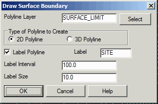 Pulldown Menu Location: Surface >> Draw
Surface
Pulldown Menu Location: Surface >> Draw
Surface
Keyboard Command: grdlimit
Prerequisite: a surface file (.GRD, .TIN, .FLT)