This feature will design a pond from a closed 2D polyline that
defines the top dam perimeter of the pond. Before beginning this
routine, you must have surface entities or surface files and a
closed polyline that represents the top of the dam. The command
creates a top of dam of the specified width, and then projects
inward to model the pond, and outward to model the slopes to match
to the target surface. Besides drawing the bench pond in 3D, the
command also reports the earthwork to build the pond and the
stage-storage data. There is also an option to output the
stage-storage data to a .CAP file to use with Draw Stage-Storage or
for hydrograph routing. After creating the pond and reporting the
earthwork and stage-storage, the program prompts whether to adjust
the design. There are three types of adjustment. One adjustment is
to balance the earthwork cut/fill by adjusting the design
elevation. Another adjustment is to resize to meet a specified
stage-storage. The target storage adjustment can be done by either
changing the pond bottom elevation or by offsetting the pond
perimeter in or out. The third type of adjustment is to manually
change one of the design parameters such as slopes or
elevations.
This command starts with the dialog shown here.
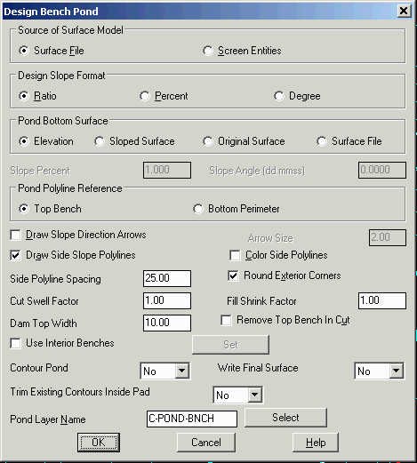
Source of Surface Model: The existing surface may defined by a 3D rectangular grid mesh (.grd file), a triangulation file (.flt or .tin file), or by screen entities. If the "Screen Entities" option is chosen, a grid file representing the existing surface will be internally created by using the user selected screen entities that depict the surface (Contours, Tri-Mesh, 3D Polys).
Design Slope Formula: Choose how you want to specify the slopes, either by ratio, percent or degree.
Pond Bottom Surface: Choose how to specify the pond
bottom surface by either the original surface, sloped surface,
surface file, or use a fixed set elevation. The Slope Surface has
settings for the slope amount and direction that the program will
use to build the bottom of pond surface. The Surface File method
will prompt for a separate TIN surface file to use for the bottom
of the pond. This method is useful for building a pond with bottom
features like a V-ditch or specific low point. For this method, the
bottom surface must be built using Triangulate & Contour before
running Design Bench Pond.
Pond Polyline Reference:
The program will prompt for you to select a pond perimeter polyline
from the drawing. With this option, you can choose between using a
perimeter polyline that represents the pond top bench or the pond
bottom perimeter.
Draw Slope Direction Arrows: This option draws an arrow on the outslopes that points in the downhill direction. Arrows on fill slopes are drawn as solid filled.
Arrow Size: Specify the
size for the slope direction arrows.
Draw Side Slope
Polylines: This option draws 3D polylines from the pond top
bench to the outside catch perimeter and inside to the pond
bottom.
Color Side Polylines:
This option will color the side slope polylines as red/blue for
cut/fill.
Side Polyline Spacing: Defines the interval along the top of pond perimeter to draw 3D lines from the top of pond to the tie at the outslope.
Cut Swell Factor: This value is multiplied by the earthwork cut volume for the report.
Fill Shrink Factor: This value is multiplied by the earthwork fill volume for the report.
Dam Top Width: Specify the width for the top of the
dam.
Remove Top Bench in Cut: If this option is checked ON and
the top of dam is in cut, then the bench will be removed.
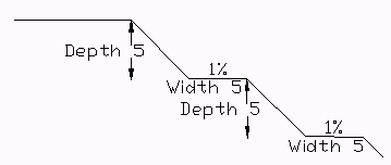
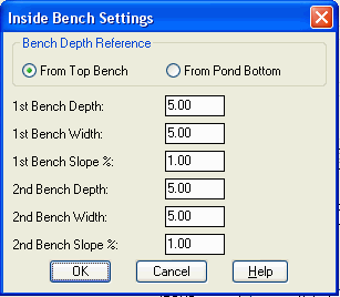
Use Interior Benches:
This option puts in up to two safety benches on the pond interior
slope. The depth for the benches can be specified from either the
top or from the bottom of the pond. If you only have one bench,
then the fields for the second bench should be set blank.
Pond Layer Name: Specify the layer for the pond entities.
The design is drawn as 3D polylines with an option to drawn contours on the pond, and the earthwork volumes and stage-storage volumes are calculated.
First the Design Bench Pond dialog box is presented.
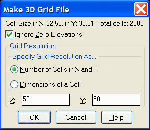
If the Source of Surface Model is set to Screen Entities,
when you pick OK you are prompted to:
Pick Lower Left limit of pond disturbed area: Pick lower
left
Pick Upper Right limit of pond disturbed area: Pick upper
right Be sure to pick these limits well beyond the area of the
top of dam polyline in order to make room for the outslopes.
Make Grid File Dialog: Specify the grid resolution desired
and select OK. Carlson Civil generates a 3D grid that
represents the existing surface, using the drawing entities that
fall within the specified area.
You are then prompted to:
Pick the top of dam polyline: Select closed
polyline
Then proceed to design the pond...
If the Source of Surface Model is set to Surface File, when you
pick OK, you are prompted to:
Pick the top of dam
polyline: Select closed polyline
Then select the
Existing Ground Surface Model file to use. Then proceed to design
the pond...
Enter the fill outslope ratio <2.0>: Enter
Enter the cut outslope ratio <2.0>: Enter
Enter the fill interior slope ratio <2.0>:
Enter
Enter the cut interior slope ratio <2.0>:
Enter
| TOP OF DAM POLYLINE |
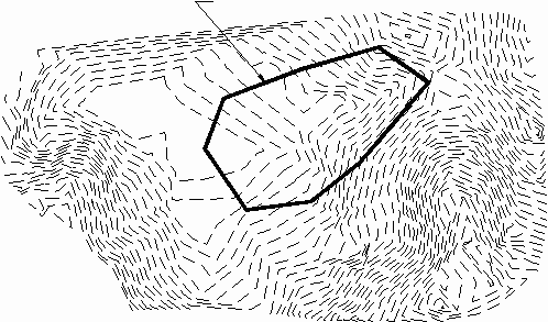
|
| Existing contours with top of dam polyline |
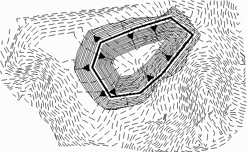
|
| Bench Pond showing Slope Direction Arrows and complete with contours |
Range of existing elevations
along dam top: 2033.75 to 2041.81
Enter the top of bank elevation <2033.75>:
press Enter to accept the default
which is the lowest surface elevation along the
perimeter
Enter the pond bottom
elevation: 2012.55
Method to specify storage
elevations [<Automatic>/Interval/Manual]?
press Enter If manual is
selected the user can specify the elevation(s) to calculate.
Pond Report viewer that shows the earthwork volumes and
stage-storage data
Adjust parameters and redesign
pond [Yes/<No>]? Y
If yes is chosen for adjust, the following 7 prompts appear along
with the report again:
Balance cut/fill
[Yes/<No>]? press
Enter for No. Yes will adjust the pond elevation to balance the
cut/fill earthwork.
Enter the fill outslope ratio
<2.00>: 2.5
Enter the cut outslope ratio <2.00>: 2.5
Enter the interior slope ratio <2.00>: 2.5
Enter the top of dam width
<10.00>: press Enter
Enter the top of bank elevation <2033.75>:
press Enter
Enter the pond bottom elevation
<2012.55>: press Enter
Offset top of dam polyline
[Yes/<No>]? Y
If yes is chosen for offset, the
following 2 prompts appear:
Offset inwards or outwards [<In>/Out]? press Enter
Enter the amount to offset:
5
Method to specify storage elevations
[<Automatic>/Interval/Manual]? press Enter
Pond Report viewer that shows the earthwork volumes and
stage-storage data
Adjust parameters and redesign
pond [Yes/<No>]? N
Write stage-storage file (Yes/<No>)? press Enter. This option
creates a .cap file to use with Draw Stage-Storage Curve and to use
for hydrograph routing.
Update target surface file [Yes/<No>]? press
Enter. This option is available when the target surface
is a triangulation file. The bench pond design will be merged into
the target surface to update the triangulation file.
Write final surface to grid
file [Yes/<No>]? press Enter
Trim existing contours inside pond perimeter
[Yes/<No>]? Y
If yes is chosen, the following 2 prompts
appear:
Retain trimmed polyline segments [Yes/<No>]? Y
Specify layer name for trimmed segments [Yes/<No>]?
press Enter
Contour the pond [<Yes>/No]? press Enter
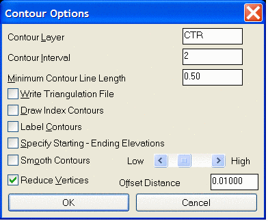
Refer to Triangulate &
Contour section of the manual for a full explanation of
Contour Options settings.
Bench Pond Design Report
Top of dam elevation: 40.0000

Bottom of pond elevation: 28.0000

Top of dam width: 10.0000

Cut slope percent grade: 40.00, slope ratio: 2.50

Fill slope percent grade: 40.00, slope ratio: 2.50

Interior slope percent grade: 50.00, slope ratio: 2.00


Lower left grid corner: 186395.20,57620.23

Upper right grid corner: 186803.82,57872.93

X grid resolution: 50, Y grid resolution: 50

X grid cell size: 8.17, Y grid cell size: 5.05


Pond EarthWork Volumes

Total fill: 2087.624 C.Y., 56365.84440 C.F.

Total cut:   772.791 C.Y., 20865.34961 C.F.
Pond Storage Volumes

Water Elev: 30.00, Pond Storage:  179.887 C.Y.,  4856.94921 C.F.

Water Elev: 32.00, Pond Storage:  453.708 C.Y., 12250.12126 C.F.

Water Elev: 34.00, Pond Storage:  817.981 C.Y., 22085.48186 C.F.

Water Elev: 36.00, Pond Storage: 1321.035 C.Y., 35667.93750 C.F.

Water Elev: 38.00, Pond Storage: 2001.216 C.Y., 54032.83340 C.F.

|
| 3D view of Bench Pond |
Pulldown Menu Location: Surface > Design Pond in
Civil, Structure in Hydro
Keyboard Command: bpond
Prerequisite: Closed polyline that defines top of dam and
surface entities