 Prompts
This command allows you to change 2D polylines to 3D polylines by elevation labels.
This command will prompt you for samples of the elevation labels and the polylines to convert. The program uses these samples to know the layer names for the labels and linework to process. Then select all the polylines with their labels you want to convert.
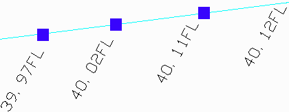
You will then be prompted to enter in an elevation to add to
label values. Often, elevations are abbreviated to save time and
space. If every elevation in a drawing is in the 500s instead of
labeling every elevation 539.97, 540.02, 540.11 sometimes, like in
the example below, they are listed as 39.97, 40.02, 40.11. This
command allows you to add a given amount, such as 500, to every
label elevation to produce the correct elevation in the
drawing.
This command will assign elevations from the labels to nearby
vertices. If vertices do not have a nearby elevation label, then
they will be interpolated from vertices that do have nearby
elevation labels.
To decide how to apply the elevation text to the polyline, the
routine computes the Center Point of the elevation text. Then the
Nearest Vertex on the polyline to the elevation text Center Point
is computed. Next the Center Point is projected onto the polyline
to calculate the Projected Point. If the Center Pointer to Nearest
Vertex distance is less than 2/3rd the Projected Point to Nearest
Vertex distance then the Nearest Vertex is elevated base on the
elevation text. Otherwise, a new vertex is inserted into the
polyline at the Projected Point, and this new vertex is elevated
based on the elevation text.
PromptsSelect sample of elevation
text: pick a text
label
Select sample of a polyline to
convert: pick a
polyline
Select polylines to convert and
elevation labels.
Select objects: select all
the entities to process
19 found, 19 total
Enter elevation to add to label values <0.00>:
500
Pre-processing entity #19 of
19
Processing elevation text #18
Remaking polyline #1
Pulldown Menu Location: 3D Data > 2D to 3D
Polyline
Keyboard Command: elevfb
Prerequisite: 2D polyline and elevation
labels