Create Vegetation Scene
This command places 3D symbols for vegetation for visualization
by commands such as 3D Viewer Window and Surface 3D Flyover. This
command is layer based where closed polylines on different layers
are used to different types of vegetation. The vegetation layers
are defined in the dialog shown here. The list shows the layer
name, symbol name and parameters for each vegetation type. Use the
Add, Edit and Delete functions to manage the list of vegetation.
The SaveAs and Load functions store and recall the vegetation
definitions to a .veg file. The Draw function creates symbols in
the drawing within closed polylines on the vegetation layers using
the vegetation parameters for symbol name, size and density. The
Hatch functions hatch the closed vegetation polylines as a way to
visualize that the vegetation areas are correctly defined. The
Create Areas function creates closed polylines on the vegetation
layers using the vegetation parameters for slopes and the specified
surface model. The Create Layers function creates the vegetation
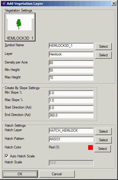
layers in the drawing if they don't already exist.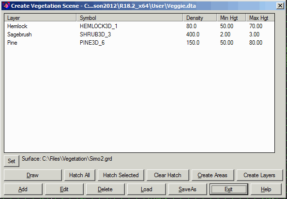 The Add and
Edit functions define the vegetation parameters in the dialog shown
here. A preview of the 3D symbol is shown along with the symbol
name. To change the symbol, type in a name or pick the Select
button to pick from the Symbol Library. There are several 3D
symbols for vegetation included in the default install under the 3D
Trees category in the symbol library. To add your own symbol to the
library, run the Settings->Symbol Library command. The symbols
should be created at unit height (height=1) so that the program can
scale to the target height. The Layer is used both for the closed
polyline for the vegetation area and for the vegetation symbols.
Density Per Acre controls how many vegetation symbols to draw with
the area. The Min/Max Heights define the range of heights for the
vegetation symbols. The program will randomly size the symbols
within this range.
The Add and
Edit functions define the vegetation parameters in the dialog shown
here. A preview of the 3D symbol is shown along with the symbol
name. To change the symbol, type in a name or pick the Select
button to pick from the Symbol Library. There are several 3D
symbols for vegetation included in the default install under the 3D
Trees category in the symbol library. To add your own symbol to the
library, run the Settings->Symbol Library command. The symbols
should be created at unit height (height=1) so that the program can
scale to the target height. The Layer is used both for the closed
polyline for the vegetation area and for the vegetation symbols.
Density Per Acre controls how many vegetation symbols to draw with
the area. The Min/Max Heights define the range of heights for the
vegetation symbols. The program will randomly size the symbols
within this range.
The Create By Slope Settings apply to the Create Areas function.
The Min/Max Slopes control the range of surface slopes that the
vegetation exists. The Start/End Directions control which slope
facing directions that the vegetation exists. The directions should
be entered in clockwise order. For example, for vegetation that
only occurs on south facing slopes, the Start Direction could be
set to 90 and the End Direction set to 270.
The Hatch Settings apply to the Hatch functions. These hatch
settings include the pattern, layer, color and scale. The Auto
Hatch Scale option sets the scale to fit within the area.
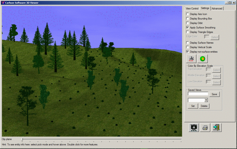
 When viewing with the 3D Viewer Window or Flyover,
use the Apply Surface Smooth, Apply Texture and Display Sky options
to improve the image.
When viewing with the 3D Viewer Window or Flyover,
use the Apply Surface Smooth, Apply Texture and Display Sky options
to improve the image.
Pulldown Menu Location: Natural Regrade
Keyboard Command: vegdef
Prerequisite: Closed polylines and surface file