This command creates a hydrograph for the runoff of one drainage area. The hydrograph is stored in a file with a .h1 extension that can be drawn with the Draw Hydrograph command or reported with the Report Hydrograph command.
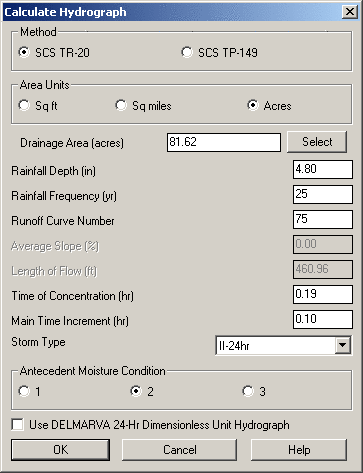
Method: Indicate the method used for determining the hydrograph:
Area Units: Indicate the unit of area for the Drainage Area control.
Drainage Area: Indicate the area that contributes to the hydrograph or click the Select button and pick a closed polyline.
Rainfall Depth: Indicate the amount of rainfall that contributes to the hydrograph.
Rainfall Frequency: Indicate the statistical probability of how often the rainfall event will occur.
Runoff Curve Number: Indicate the land use curve number that determines how much surface runoff will occur.
Average Slope: When using the TP-149 methodology, indicate the average slope of the flow path.
Length of Flow: When using the TP-149 methodology, indicate the slope length of the flow path.
Time of Concentration: When using the TR-20 methodology, indicate the Time of Concentration (Tc) value.
Main Time Increment: When using the TR-20 methodology, indicate the Time increment.
Storm Type: When using the TR-20 methodology, indicate the Storm Type that should be used for the calculations.
Antecedent Moisture Conditions: When using the TR-20 methodology, indicate the amount of moisture already in the soil.
Use DELMARVA 24-Hr Dimensionless Hydrograph: When enabled and when using the TR-20 methodology, a DelMarVa 24-hr Unit Hydrograph will be applied to the hydrograph calculations.
Pulldown Menu Location: Watershed > TR-20
Routing
Keyboard Command: calchgrf
Prerequisite: None