This command draws a 3D polyline starting at a picked point and
going downhill until reaching a local minimum or end of the
surface. In effect this flow line simulates the path of a rain
drop. The program also reports the distance and slope of the flow
line. These values can be used in time of concentration
calculations. This command uses a grid model for the surface which
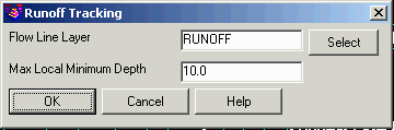
works well for existing ground surfaces. The Run Off Tracking
command that is in the main Watershed menu works with triangulation
surfaces which works well for design surfaces.
In the options dialog, the Max Local Minimum Depth is the most
the program will allow the flow to jump over.
Select Surface Model Choose .grd file
Watershed options dialog
Pick origin point of rain drop: pick a point
Horizontal distance: 10315.58, Slope distance: 10392.95
Vertical drop: 982.08, Avg slope: 9.52%, Max slope: 52.34%
Pick origin point of rain drop (Enter to end): press
Enter
Pulldown Menu Location: Watershed > Watershed By Grid
Surface
Keyboard Command:
runoff_grd
Prerequisite: surface .GRD file