Curve Numbers (CN) & Runoff
This command calculates the weighted curve number (CN) as used
by the SCS Method of runoff calculation. It will also calculate
total, potential runoff from an area. The curve number is used by
routines based on the TR-55 program. The weighted curve number is a
weighted average of the curve numbers for each subarea of the
watershed. The weights are based on the areas. The Description and
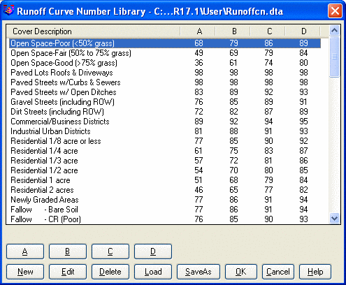
Soil Type fields are used in the report. Shown here is the Curve
Number Library from which to select curve numbers. The initial
Curve Number Library is taken from the SCS TR-55, Urban Hydrology
for Small Watersheds. You can modify the library using the New and
Edit buttons and you can use the Load and SaveAs buttons to store
the library to separate .rcn files.
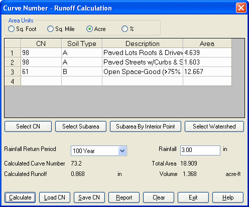
First highlight a row on the
spreadsheet, and then select the curve number from the library
using the Select CN button and click on the Select Subarea button
to select all the subarea closed polylines. These polylines can be
generated by the Sub-Watershed by Land Use command. The program
will sum the polylines that are selected for a total area. The
Subarea By Interior Point button allows you to select subarea
closed polylines by picking inside the polylines. If you have the
runoff layers defined for the watershed beforehand, you can
simplify the process by selecting the closed polyline of the whole
watershed, the subareas and their curve numbers, soil types, cover
descriptions as well as area values will be filled into the
spreadsheet automatically. More information regarding the soil
types in given below.
When all the land-use curve numbers and areas are entered, enter
the rainfall for the storm in question and then click on the Calc
button to calculate the weighted curve number and the runoff given
the weighted curve number. This curve number can then be used in
the Time of Concentration and Peak Flow commands. The Runoff Volume
equals the Runoff Q times the total area. You can also save the
table entries to a curve number (.cn) file and reload these values
later.
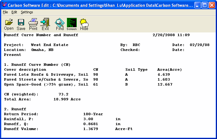
A typical Report is shown
here:
The following information regarding soil types comes from Part 630
of the National Engineering Handbook. This can be found at the
following link:
https://directives.sc.egov.usda.gov/OpenNonWebContent.aspx?content=17757.wba
The four hydrologic soil groups (HSGs) are described as:
Group A—Soils in this group have low runoff potential when
thoroughly wet. Water is transmitted freely through the soil. Group
A soils typically have less than 10 percent clay and more than 90
percent sand or gravel and have gravel or sand textures. Some soils
having loamy sand, sandy loam, loam or silt loam textures may be
placed in this group if they are well aggregated, of low bulk
density, or contain greater than 35 percent rock fragments. The
limits on the diagnostic physical characteristics of group A are as
follows. The saturated hydraulic conductivity of all soil layers
exceeds 40.0 micrometers per second (5.67 inches per hour). The
depth to any water impermeable layer is greater than 50 centimeters
[20 inches]. The depth to the water table is greater than 60
centimeters [24 inches]. Soils that are deeper than 100 centimeters
[40 inches] to a water impermeable layer are in group A if the
saturated hydraulic conductivity of all soil layers within 100
centimeters [40 inches] of the surface exceeds 10 micrometers per
second (1.42 inches per hour).
Group B—Soils in this group have moderately low runoff potential
when thoroughly wet. Water transmission through the soil is
unimpeded. Group B soils typically have between 10 percent and 20
percent clay and 50 percent to 90 percent sand and have loamy sand
or sandy loam textures. Some soils having loam, silt loam, silt, or
sandy clay loam textures may be placed in this group if they are
well aggregated, of low bulk density, or contain greater than 35
percent rock fragments. The limits on the diagnostic physical
characteristics of group B are as follows. The saturated hydraulic
conductivity in the least transmissive layer between the surface
and 50 centimeters [20 inches] ranges from 10.0 micrometers per
second (1.42 inches per hour) to 40.0 micrometers per second (5.67
inches per hour). The depth to any water impermeable layer is
greater than 50 centimeters [20 inches]. The depth to the water
table is greater than 60 centimeters [24 inches]. Soils that are
deeper than 100 centimeters [40 inches] to a water impermeable
layer or water table are in group B if the saturated hydraulic
conductivity of all soil layers within 100 centimeters [40 inches]
of the surface exceeds 4.0 micrometers per second (0.57 inches per
hour) but is less than 10.0 micrometers per second (1.42 inches per
hour).
Group C—Soils in this group have moderately high runoff potential
when thoroughly wet. Water transmission through the soil is
somewhat restricted. Group C soils typically have between 20
percent and 40 percent clay and less than 50 percent sand and have
loam, silt loam, sandy clay loam, clay loam, and silty clay loam
textures. Some soils having clay, silty clay, or sandy clay
textures may be placed in this group if they are well aggregated,
of low bulk density, or contain greater than 35 percent rock
fragments. The limits on the diagnostic physical characteristics of
group C are as follows. The saturated hydraulic conductivity in the
least transmissive layer between the surface and 50 centimeters [20
inches] is between 1.0 micrometers per second (0.14 inches per
hour) and 10.0 micrometers per second (1.42 inches per hour). The
depth to any water impermeable layer is greater than 50 centimeters
[20 inches]. The depth to the water table is greater than 60
centimeters [24 inches]. Soils that are deeper than 100 centimeters
[40 inches] to a restriction or water table are in group C if the
saturated hydraulic conductivity of all soil layers within 100
centimeters [40 inches] of the surface exceeds 0.40 micrometers per
second (0.06 inches per hour) but is less than 4.0 micrometers per
second (0.57 inches per hour).
Group D—Soils in this group have high runoff potential when
thoroughly wet. Water movement through the soil is restricted or
very restricted. Group D soils typically have greater than 40
percent clay, less than 50 percent sand, and have clayey textures.
In some areas, they also have high shrink-swell potential. All
soils with a depth to a water impermeable layer less than 50
centimeters [20 inches] and all soils with a water table
(210–VI–NEH, May 2007) 7–3 Part 630 National Engineering Handbook
Chapter 7 Hydrologic Soil Groups within 60 centimeters [24 inches]
of the surface are in this group, although some may have a dual
classification, as described in the next section, if they can be
adequately drained. The limits on the physical diagnostic
characteristics of group D are as follows. For soils with a water
impermeable layer at a depth between 50 centimeters and 100
centimeters [20 and 40 inches], the saturated hydraulic
conductivity in the least transmissive soil layer is less than or
equal to 1.0 micrometers per second (0.14 inches per hour). For
soils that are deeper than 100 centimeters [40 inches] to a
restriction or water table, the saturated hydraulic conductivity of
all soil layers within 100 centimeters [40 inches] of the surface
is less than or equal to 0.40 micrometers per second (0.06 inches
per hour).
Dual hydrologic soil groups—Certain wet soils are placed in group D
based solely on the presence of a water table within 60 centimeters
[24 inches] of the surface even though the saturated hydraulic
conductivity may be favorable for water transmission. If these
soils can be adequately drained, then they are assigned to dual
hydrologic soil groups (A/D, B/D, and C/D) based on their saturated
hydraulic conductivity and the water table depth when drained. The
first letter applies to the drained condition and the second to the
undrained condition. For the purpose of hydrologic soil group,
adequately drained means that the seasonal high water table is kept
at least 60 centimeters [24 inches] below the surface in a soil
where it would be higher in a natural state.
Matrix of hydrologic soil group assignment criteria—The decision
matrix in tables 7–1 and 7–2 can be used to determine a soil’s
hydrologic soil group. Check both tables before making a final
decision. If saturated hydraulic conductivity data are available
and deemed to be reliable, then these data, along with water table
depth information, should be used to place the soil into the
appropriate hydrologic soil group. If these data are not available,
the hydrologic soil group is determined by observing the properties
of the soil in the field. Factors such as texture, compaction (bulk
density), strength of soil structure, clay mineralogy, and organic
matter are considered in estimating the hydraulic conductivity of
each layer in the soil profile. The depth and hydraulic
conductivity of any water impermeable layer and the depth to any
high water table are used to determine correct hydrologic soil
group for the soil. The property that is most limiting to water
movement generally determines the soil’s hydrologic group. In
anomalous situations, when adjustments to hydrologic soil group
become necessary, they shall be made by the NRCS state soil
scientist in consultation with the state conservation engineer.
Pulldown Menu Location: Watershed
Keyboard Command: curveno
Prerequisite: None