 Keyboard Command:
report_strata_pline
Keyboard Command:
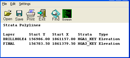
report_strata_plineThis command generates a report using the Report Formatter
containing all the Strata Polylines automatically found in the
drawing. It reports the layer, XY of the start and end of the
polyline, the tagged strata name and the type (elevation or
thickness). Keyboard Command:
report_strata_pline