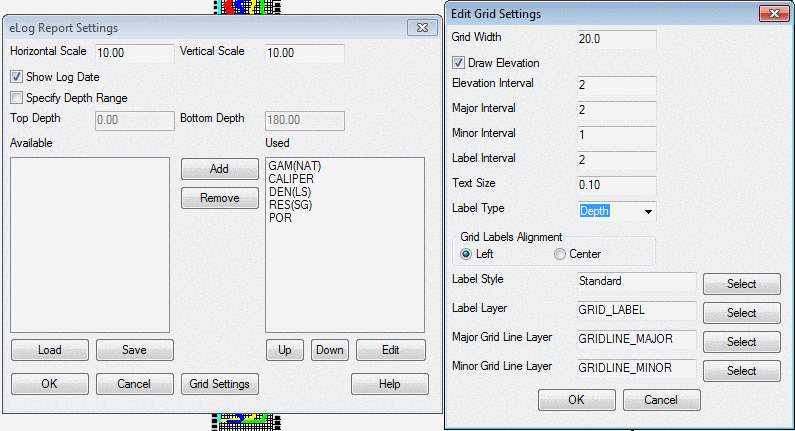
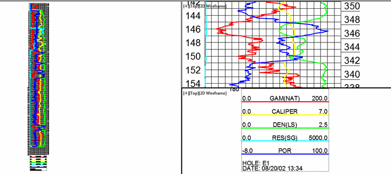
Draw E-Logs
This command takes a standard LAS file and draws the eLog data in
CAD as linework, ready for analysis and plotting. It can be drawn
next to an existing geologic column, or drawn by itself. LAS files
are standard formats of electronic logs. The header data can vary,
but the program reads through it and automatically find the Gamma,
Caliper, Density, Resistivity and Por. The Automatic Mode draws the
eLog next to existing geologic columns draw by the Draw Geologic
Column command. For the Automatic Mode, there are settings for how
far to draw the eLog to the left or right of the geologic columns,
and for the folder with the LAS files. The program will match
drillhole names in the drawing with the LAS file names in this
folder.
Here is a sample LAS file format. The header data might be
different for other files, but the program should recognize the
columns either way.
~Version Information
VERS.
2.0: CWLS LOG ASCII STANDARD -VERSION 2.0
WRAP.
NO: ONE LINE PER DEPTH STEP
~WELL INFORMATION BLOCK
#MNEM.UNIT
DATA
DESCRIPTION OF MNEMONIC
#---------
-------------
------------------------
STRT.FT
0.400
:START DEPTH
STOP.FT
170.300
:STOP DEPTH
STEP.FT
0.100
:STEP UP_HOLE
NULL.
-999.25
:NULL VALUE
COMP.
TST :COMPANY
WELL.
E1 :WELL
FLD
.
AREA Z :FIELD
LOC
.
:LOCATION
CNTY.
MASON :COUNTY
STAT.
KENTUCKY :STATE
SRVC.
CARLSON
:SERVICE COMPANY
DATE.
08/20/02
:LOG DATE
UWI
.
:UNIQUE WELL ID
LIC
.
:LICENSE NUMBER
~Curve Information Block
#MNEM.UNIT API
CODE Curve Description
#--------- -------------
------------------------
DEPT
.FT 00 001 00
00 :
1 DEPTH
GAM(NAT) .API-GR 00 310 00
00 :
2
GAM(NAT)
CALIPER .INCH 00 280 00
00 :
3
CALIPER
DEN(LS) .G/CC 00 350 00
00 :
4
DEN(LS)
RES(SG) .OHM-M 00 220 00
00 :
5
RES(SG)
POR .PERCENT 00 890
00 00 :
6
POR
~Parameter Information Block
#MNEM.UNIT Information
Description
#---------- --------------- ------------------------
FILE.
PROCESSED
:File Type
FIID.
9039A
:File Type Identifier
VERS.
1.0
:System Version
SER .
1
:System Serial Number
TRUK.
0.4966
:Truck Calibration Number
TOOL.
952
:Tool Serial Number
TIME.
1334
:Time HrHrMinMin
LAT
.
:Latitude
LON
.
:Longitude
LMF
.
GL :Log
Measured From
DMF
.
GL
:Driller Measured From
PD
.
GL
:Permanent Data
PDEV.
:Elevation Permanent Data
EKB
.M
:Elevation Kelly Bushing
ELEV.DF
:Elevation DF
EGL .M
490.6
:Elevation Ground Level
DRDP. 170
DW
:Driller's Depth
CASD.
:Casing Diameter
CASB.
:Casing Bottom
CASX.
:Casing Type
CAST.
:Casing Thickness
TNOC.
:Time Circulation Stopped
LOGU.
561
:Logging Unit
RECB.
B. MATAS :Recorded By
OSR1.
:Other Services
OSR2.
:Other Services
OSR3.
:Other Services
BS .MM
4.75
:Bit Size
MST
.
:Mean Surface Temperature
TGRD.
:Temperature Gradiant
MAGN.
0
:Magnetic Declination
MDEN.
2.65
:Density Matrix
MATR.
SANDSTONE
:Neutron Matrix
DTMT.
54
:Delta T Matrix
DTFL.
:Delta T Fluid
MUDS.
:Mud Sample Source
MRS
.
:Mud Resistivity
MTP
.
:Mud Temperature
MFRS.
:Resistivity Mud Filtrate
MFTP.
:Temperature Mud Filtrate
MCRS.
:Resistivity Mud Cake
MCTP.
:Temperature Mud Cake
FTYP.
WATER
:Fluid Type
FD
.K/M3
:Fluid Density
DFV
.S
:Fluid Viscosity
FPH
.
:Fuild PH
ELCO.
5000
:Electron Cutoff
~Other Information
#MNEM.UNIT Information
Description
#---------- --------------- ------------------------
# --------------------------
~A DEPTH GAM(NAT) CALIPER DEN(LS) RES(SG) POR
0.400 -999999.0 -999999.0 -999999.00 -999999.0
-999999.0
0.500 -999999.0 -999999.0 -999999.00 -999999.0
-999999.0
0.600 26.3
0.0
0.00 0.0
0.0
0.700 26.3
0.0
0.00 0.0
0.0
0.800 46.1
0.0
0.00 0.0
0.0
0.900 39.5
0.0
0.00 0.0
0.0
1.000 23.0
0.0
0.00 0.0
0.0
1.100 28.5
0.0
0.00 0.0
0.0
1.200 55.9
0.0
0.00 0.0
0.0
1.300 29.6
0.0
0.00 0.0
0.0
1.400 36.2
0.0
0.00 0.0
0.0
1.500 59.2
0.0
0.00 0.0
0.0
1.600 42.8
0.0
0.00 0.0
0.0
1.700 29.6
0.0
0.00 0.0
0.0
1.800 32.9
0.0
0.00 0.0
0.0
1.900 49.3
0.0
0.00 0.0
0.0
2.000 36.2
0.0
0.00 0.0
0.0
Prompts
Add strata to top or
bottom of drillhole [<Top>/Bottom]? Top
(in this example)
Enter strata name: Topsoil
Enter bed name: Top
Status for strata [<Key>/Non-key]? N
Enter strata thickness: 1.0
Select the Drillholes to process. Type ALL or select.
Updated 13 drillholes:
Pulldown Menu Location: Drillhole > Strata/Bed
Utilities
Keyboard Command: addstrata
Prerequisite: Drillholes