This command outputs point data from the current Carlson
coordinate file to an ASCII text file formatted according to a
variety of options presented in the form of a general dialog.
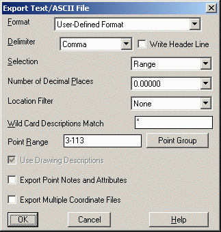
Format. Specify the type of file to
write from the drop down list. There are several variations on
point number, northing, easting, elevation and descriptions as well
as specific formats for Leica, Geodimeter, Zeiss, Maptech, Idan
REG, NLS MMH360, D45, Cadvantage, Multiplane and SDMS CTL formats.
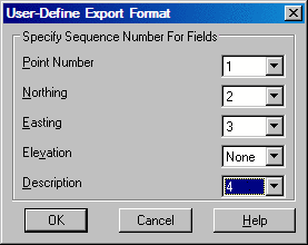
In addition there is a User-Defined Format option to define the
order of the fields output. When using the User-Defined format,
after selecting OK, the User-Define Export Format dialog will
appear. On this dialog, specify the order of the fields by defining
a number sequence in each field. You can skip fields and omit data
in the output file by leaving None in the sequence field for this
data:
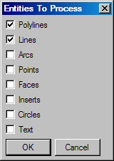
Selection. There are four Selection Methods provided for the data to export. Specify either Range, Screen Points, Screen Entities or Pick Points in the Selection Field. A Range selection is a user specified range such as 1-10,30-50. A Screen Points selection is made by selecting points from the screen area. The Pick Points method prompts to select the points to export from the drawing. The Screen Entities option allows for selection of polylines, lines, arcs, points, faces, inserts and text to export point data from. When the Screen Entities option is selected, the following dialog box will display allowing for the specification of the type of entity to export data from:
Delimiter. Select the
desired field delimiter of the export file as either Comma or Space
from the drop down list. If a header line is to be included, enable
the check box.
Number of Decimal
Places. Select the desired number of digits to be included
in the mantissa of all output ordinates.
Location Filter. Choose
from filter methods of within inclusion perimeter polyline, by
coordinate window or center within radius from a center
point.
Wild Card Descriptions
Match. A description filter is also available for exporting
only points from the range or selection set with certain
descriptions.
Export Point Notes and Attributes. Notes associated with the points may be included in the export by enabling the check box.
Export Multiple Coordinate
Files. Enable this check box to specify multiple CRD files
to apply the selection criteria against. If enabled, an additional
dialog will be presented from which you can browse, select, and
remove as many CRD files as desired. In this mode, you can use the
Write To Single ASCII File to output the multiple coordinate files
into one combined text file.
Point Group. Displays
the Point Group manager dialog from which you may define, modify,
and select one or more Point Groups to define the points to be
included in the export.
After selecting the OK button, a final dialog appears that allows you to specify a new file or to append data into an existing file. The standard file selection dialog allows you to specify the export file name.
Pulldown Menu Location: Points
Keyboard Command: writept
Prerequisite: A Coordinate File (.CRD)