Pulldown Menu Location: GIS Data ->
Import GIS Data -> Import from SQLite
Keyboard Command: import_sqlite
Keyboard Command: import_sqlite
The import SQLite file commands convert SQLite with spatial
capapilities DB files into Carlson drawing entities. It is
optionally write the available attribute data to an ESRI MSC/Map
Object Data and create GIS links between the drawing entities and
the records in the database. If SQLite/Spatial DB is selected
as the GIS Data Format in the Drawing Setup dialog, then the
program will only create GIS links between the drawing entities and
the records in the database.
There are primarily three types of DB files: Points, LineStrings
and Polygons. Each will provide different options on
Import. Once the GML file is selected, Carlson detects the
data contents of the file and sets the dialog options for importing
either polygons, linestring or points. Carlson GIS also
supports the use of three other types of DB files: MultiPoint,
MultiLineString and MultiPolygon. LineStrings are brought
into Carlson as open polylines and Polygons are as closed polylines
in the drawing.
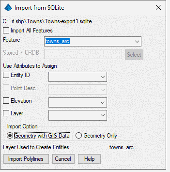
Import from SQLite dialog will list all available tables in the
DB File. The user can select import all tables or one of the
tables in the list. Then select corresponding fields for the Point
ID/Entity ID, Description, Elevation and Layer, etc. The
selected fields would be used to fill Carlson internal
fields. If no field is selected for Point ID/Entity ID, then
the program will create an unique ID for each entity. If no
field is selected for Point Desc, then the description will leave
blank. If no field is selected for Layer, then the table name
will be used as layer name. If the feature type is
Point/MultiPoint, then it will allow user to select a name for the
CRDB. The program then will also output points geometry and
GIS Data to CRDB.