re-Associate Coord. file
This routine allows you to associate the current drawing file with
different coordinate file than created the drawing file. An
example of this could be a phase of a project. The overall
project coordinate file might contain 10,000 to 15,000
coordinates, While working on a phase of the overall project
a separate, smaller, coordinate file was created, easier to
work with a 1000 points rather than 15,000. Now you want to
re-associate this new drawing file with the overall project
coordinate file.
Prompts
After selecting the re-Associate command there will be displayed a
Warning dialog box. This box recommends that you create a
backup of your drawing file. The danger with using this
application is if the coordinates are not managed carefully and the
same point ID’s were used in both the overall project file and the
out parcel then the graphics will be incorrect. C&G
graphics are based on the coordinate file and if the X/Y/Z values
change so does the graphics.
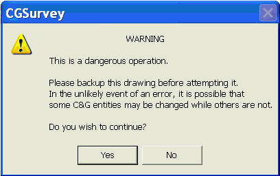
Do you wish to Continue? Press
<Y> button: Y
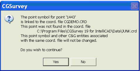
Re-associate only those C&G
entities plotted using which coord. file [Any_file]
<A>: A
An Additional Warning message may also appear indicating conflicts
in linked crd files
Do you wish to Continue? Press
<Y> button: Y
Pulldown Menu Location:
CG-Survey > CGDraw>re-Associate Coord. file
Keyboard Command: Not
available
Prerequiste:
Coordinate file