Best Fit Curve
This command draws an arc between two endpoints with a radius
that is derived from sampling points. Least-squares is used to find
the radius for the closest arc that passes through these points.
The Hold End Points option applies additional weight to the end
points by the specified weight factor. After specifying the points,
the program calculates the best-fit arc and shows the results in
the dialog show here. You can toggle each point for whether to
include in the calculations. When a point is toggled off for
processing, it is not used to calculate the best-fit arc but the
residual is still reported. Use the Remove button to remove a point
both from calculation and reporting. You can also modify the
radius. After picking OK, the arc is drawn in the current layer and
there is a report.
Prompts
Starting Point ?
Pick point or point number: 46
Ending point ?
Pick point or point number: 50
Select points from screen, group or by point number
[<Screen>/Group/Number]? press Enter
Select Carlson Software Points.
Select objects: pick points
Hold end points
[Yes/<No>]? press Enter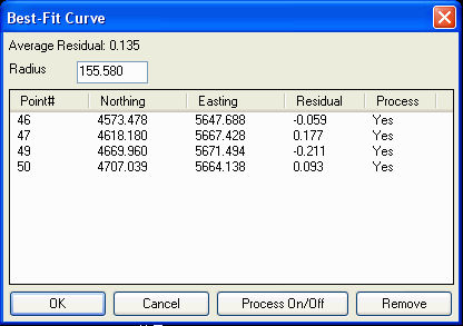 Best Fit Arc
Coordinate File> C:\sample\PLAT.CRD
Source Coordinates
Point# Northing
Easting Residual
46 4573.478
5647.688 -0.059
47 4618.180
5667.428 0.177
49 4669.960
5671.494 -0.211
50 4707.039
5664.138 0.093
Residuals Standard Deviation: 0.148
Average Residual: 0.135
Circle Center: 4657.233,5516.647
Radius: 155.580
Pulldown Menu Location: Draw > Arc
Keyboard Command: bfitcrv
Prerequisite: Points for sampling should be drawn before
execution.