This feature allows you to convert longitude and latitude to and
from NAD83 state plane coordinate systems. NOTE: Do not use this
function for any other coordinate system, i.e. NAD 1927. Make sure
the correct state is selected on the General tab of the C&G
Options dialog box.
After choosing the NAD83 menu item from the CGCogo menu you will be
prompted for the necessary data.
At the Enter zone prompt enter the letter for the appropriate zone
for the area where the survey was performed. The zones allowed may
vary by state.
[Coords to longitude-latitude/Longitude-latitude to coordinates]
<C>:
Coords to
longitude-latitude
Pressed <Enter> (or type C and <Enter>)
you will be asked to select the points.
After selecting points a table of longitude-latitude and related
data for the points will be printed at the command line
Longitude-latitude to
coordinates
Type L and <Enter>,
You will be asked to enter the longitude and latitude of the points
you wish to calculate
When you have entered the final longitude-latitude pair press
<Enter> when asked for the next latitude.
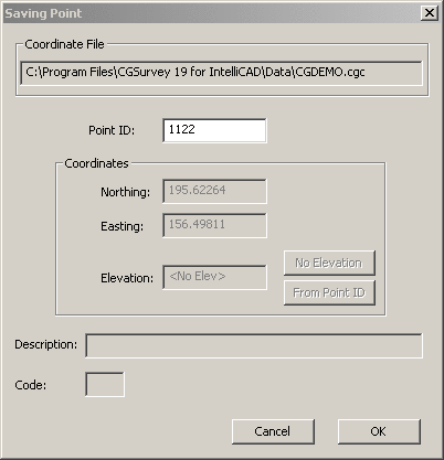
The computed points will be stored in the coordinate file
using the Saving Point dialog shown below.
Click OK to save the point to the
coordinate file.
Repeat until done or press <Enter> to end the command.
Prompts
Enter zone (E, W): enter
the letter for the appropriate zone for the area where the survey
was performed. The letters allowed will vary depending on the
state. [Coords_to_longitude_latitude/Longitude_latitude_to_coords]
<C>: Type "C" and Enter or just Enter to calculate
coordinates given longitude and latitude. Type "L" and Enter to do
the reverse.
if you chose Coords to longitude-latitude: Choose initial points for base
selection set from coord file. (Enter when done) [All/Block/Code/Desc/Elev/Pt_group/Limits/Radius/Select]:
Use the various selection methods to choose the points for which
you wish to calculate longitude and latitude
if you chose Longitude-latitude to Coords: Enter latitude [<Enter> when
done]: Enter the latitude angle for a longitude -
latitude pair. Enter longitude: Enter the
longitude angle for a longitude - latitude pair.