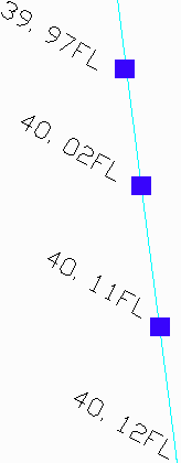
You will then be prompted to enter in an elevation to add to label values. Often times elevations are abbreviated to save time and space. If every elevation in a drawing is in the 500s instead of labeling every elevation 539.97, 540.02, 540.11 sometimes, like in the example on the side, they are listed as 39.97, 40.02, 40.11. This command allows you to add a given amount, such as 500, to every label elevation to produce the correct elevation in the drawing. This command will assign elevations from the labels to nearby vertices. If vertices do not have a close elevation label than they will be interpolated from vertices that are nearby elevation labels. The vertices elevated in this command will appear as control vertices in the command Edit-Assign Polyline Elevations. It can also be used in conjunction with other 2D to 3D commands to elevate polylines by more than one method.
