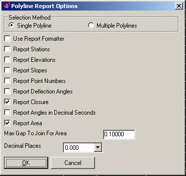
This command generates a report of data in the selected
polylines. After starting the command, press O for Options to set
various report options. When the Report Points option is active,
the report includes the coordinates, angle-distance and curve data
for all the points. With Report Points turn off, the report
includes just the perimeter, area and layer names of the polylines.
The closure can be reported between the starting and ending points
of the polyline. The polyline area can also be reported. With the
Multiple Polylines option, you can report a selection set of
polylines with their total length at the end of the
report.
Polyline Report
Northing Easting Bearing Distance
4657.495 5452.844
N 40°45'51" E 84.323
4721.362 5507.902
Radius: 175.795 Chord: 249.282 Degree: 32°35'33" Dir: Right
Length: 277.088 Delta: 90°18'35" Tangent: 176.747
Chord BRG: N 85°55'08" E Rad-In: S 49°14'09" E Rad-Out: S 41°04'26" W
Radius Point: 4606.577,5641.050
4739.102 5756.552
S 24°29'28" E 122.817
4627.336 5807.466
S 74°29'33" W 199.062
4574.114 5615.650
N 62°53'05" W 182.885
4657.470 5452.866
Closure Error Distance> 0.03419 Error Bearing> N 41°22'21" W
Closure Precision> 1 in 25333.8 Total Distance> 866.174
Polyline Area: 47735.6 sq ft, 1.1 acres
Options/Select polyline to report: pick a
polyline
Standard Report Viewer Displays the report for the selected
polyline.
Options/Select polyline to report (Enter to End): press
Enter
Pulldown Menu Location: Survey > Polyline Tools
Keyboard Command: plreport
Prerequisite: A polyline