
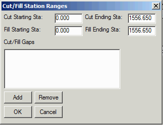
Range of Stations: The program will pick up the range of stations determined by your section files. In this field, you can modify the range of stations to process. The Settings button brings up another dialog with more station options:
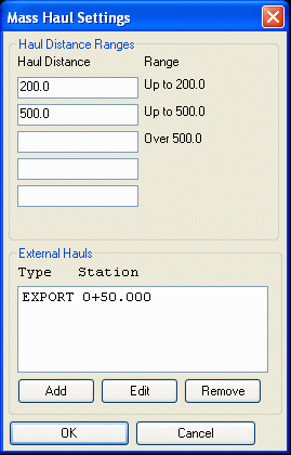
This command will determine the volume and haul distance for
each group of net cut and net fill station ranges along a
road. The program calculates the optimized cut to fill
movements so that the total volume-distance moved is
minimized.
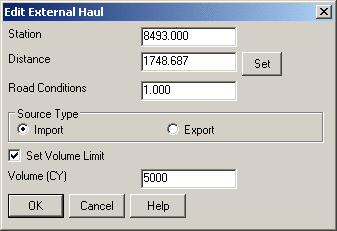
You will first be prompted to select the Existing Ground section file and the Design Surface section file or on End Area (.ew) file. These files will be used to determine the Mass Haul quantities. If you do not have either of these files, you can create them using the different Create Sections commands under Roads. After you selected your section (.sct) files or (.ew) file, the following dialog will appear.
Range of Stations: The program will pick up the range of
stations determined by your section files. In this field, you can
modify the range of stations to process. The Settings button brings
up another dialog with more station options:
Mass Haul Analysis
Existing Section> C:\Takeoff\Drawings\demo2-og.sct
Final Section>
C:\Takeoff\Drawings\demo2-fn.sct
Volumes per Range Average Haul per Range
Net Cut Net
Fill
Total In Sta
Haul
0
200 Over
0
200 Over
Station Station
Cut(CY) Import Fill(CY) Export
Volume Volume
Volume
200 500
500 200
500 500 Overall Avg
0+00.000 1+00.000
1+00.000 2+50.000
1251.729 0.000 1251.729 0.000
1251.729 1127.595 124.134 124.134
0.000 0.000 153.135 0.000 0.000 153.135
12+00.000 10+50.000
13+80.000 12+00.000 887.367
0.000 887.367 0.000 887.367
239.938 647.429 542.651 104.777
0.000 164.552 209.534 0.000 179.887
13+70.000 15+05.340
13+90.000 15+23.200
95.633 0.000 95.633
0.000 95.633 51.559
44.074 44.074 0.000
0.000 137.235 0.000 0.000 137.235
13+80.000 14+20.000
14+20.000 14+50.000 216.434
0.000 216.434 0.000
216.434 96.872 119.563
119.563 0.000 0.000
38.560 0.000 0.000 38.560
14+60.000 14+50.000
14+80.000 14+60.000
43.333 0.000 43.333
0.000 43.333 18.620
24.712 24.712 0.000
0.000 11.818 0.000 0.000 11.818
14+70.000 15+00.000
15+00.000 15+14.270
82.194 0.000 82.194
0.000 82.194 29.738
52.456 52.456 0.000
0.000 24.395 0.000 0.000 24.395
Total:
9808.744 0.000 69788.70 0.000
74189.76 66786.40 7403.360 1288.814 930.060
783.423 127.043 209.534 0.000 130.579
Pulldown Menu Location: Sections
Prerequisite: A Section Alignment File and Existing and Road
Sections
Keyboard Command: masshaul