This command calculates the elevation and slope along a profile at user specified stations or intervals. The routine allows three types of Reference Profile input options: Profile File (an existing .PRO file), Screen Profile (existing grid and polyline profile), or None (allows you to specify station-elevation points without referencing a profile). If the Screen Profile option is used, the profile polyline direction must match that of the stationing on the grid.
There are two Output Options: Report and Label Profile.
The Report option will send the output data to the standard report
viewer, which can then be printed, saved to a file or plotted in
the drawing. The Label Profile option will create text on the
existing grid and polyline profile. With either option, the user
will be prompted to enter or pick the station to report unless the
Report at Interval option is checked on. In this case, the
reporting will be done automatically at the interval specified.
With the Label Profile option, the user has the additional options
for defining the data to be labeled (Station, Elevation, Both or
None), the slope format and the vertical position of the text on
the grid. The Label Orientation choose between horizontal
and vertical labels.
This command can also be used as a profile inspector. As you
move the cursor around, the station, elevation and profile grade
are displayed in a real-time window, unless you specify the more
automatic "report at interval" method. If Prompt for snap is set on
(available in non-interval mode), then when a point on the profile
is picked, you have the opportunity to snap to an even 1, 5 or 10
stations.
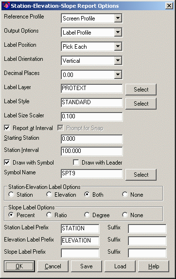
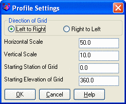
Station-Elevation-Slope Report Options dialog
Profile Settings dialog Check that these parameters match the
grid.
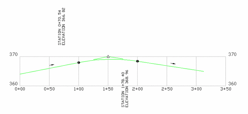
Pick Lower Left Grid Conner <5177.48,5034.10>[end on]:
pick the corner (endpoint snap is on)
Pick profile polyline: pick the profile polyline
Range of Stations > 0.0 - 312.43
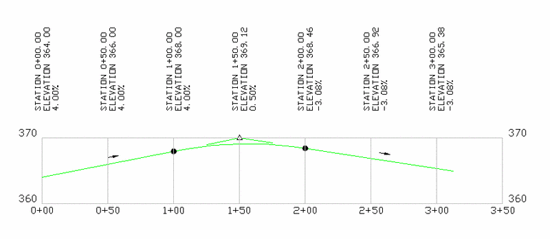
Station> 0+00.00 Elevation> 364.00 Slope> 4.00%
Pick the vertical position for the text: pick a point
to place the text
Station> 0+50.00 Elevation> 366.00
Slope> 4.00%
Station> 1+00.00 Elevation>
368.00 Slope> 4.00%
Station> 1+50.00 Elevation>
369.12 Slope> 0.50%
Station> 2+00.00 Elevation>
368.46 Slope> -3.08%
Station> 2+50.00 Elevation>
366.92 Slope> -3.08%
Station> 3+00.00 Elevation>
365.38 Slope> -3.08%
|
|
|
|
| Picked method with Slope set to None |
|
|
| Interval method with Slope in Percent |