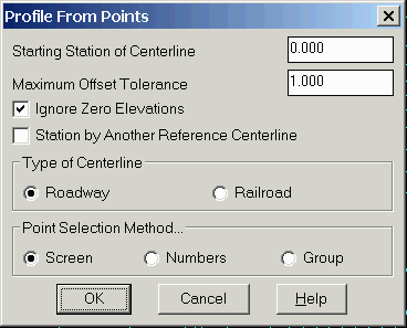
This command creates a .PRO file from points and a centerline
that is represented by a polyline or centerline file. The
elevations of the profile are derived from the elevation of the
points and the stationing for these profile points is calculated
from the distance along the centerline. The points must be within
the offset distance from the polyline in order to be included in
the profile. The profile is created by projecting the points
perpendicular onto the alignment to determine the station and the
elevation comes from the point elevation. The polyline or
centerline should be drawn (or defined) in the direction of
increasing stations. The points can be selected from point
entities in the drawing (Screen), by point numbers from the current
coordinate file (Numbers), or by point group as defined by the
Point Group Manager (Group).
PROfile file to Write dialog box: Enter a new profile
file name to write.
CL File/<Select polyline that represents centerline>:
pick a polyline or choose C for Centerline
Select Centerline file if Centerline option is used. If the desired
points are further from the centerline, enter a larger maximum
offset tolerance.
Note: for all selected points, the points should be located on the
real Z axis.
Select the Carlson points along the centerline.
Select objects: Select the point entities.
Keyboard Command: profpts
Prerequisite: A polyline centerline and points