Cut/Fill Report
This command reports the cut/fill between two surfaces at an
interval. The existing and design surfaces can be either
triangulation (TIN) or grid (GRD). After selecting the surfaces,
the program prompts for optional inclusion and exclusion polylines
to control the report area. Then there is an options dialog. The
report works with the Report Formatter for choosing which fields to
show including cut/fill, existing elevation, design elevation,
northing and easting.
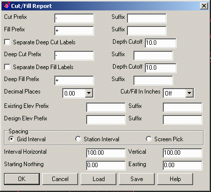
In the options dialog, you can customize the Cut/Fill labels. Text
can be added either before or after the Cut/Fill amount, the
Existing elevation, and the Design elevation with the Prefix and
Suffix fields. Decimal Places sets to how many decimal places the
labels will report. The Cut/Fill In Inches labels in feet and
inches to the specified precision. The Separate Deep Cut/Fill
Labels settings allow for highlighting deep areas by changing
prefix/suffix labels.
The Spacing methods include:
Grid Interval: Places the labels at the specified Horizontal and
Vertical Intervals starting with the specified Northing and Easting
coordinate.
Station Interval: Uses a centerline polyline and places the labels
at a station interval along this alignment.
Screen Pick: Prompts for each label position.
Pulldown Menu Location: Surface> Cut/Fill
Utilities
Keyboard Command: cfreport
Prerequisite: Existing and design surfaces