The program internally computes BASE and FINAL grid surfaces
from drawing geometry. The base surface is calculated from a 3D
polyline representing the perimeter of the area being analyzed. If
that 3D polyline is drawn on the PERIMETER layer, the command will
automatically detect and use it. If no 3D polyline is found
on that layer, you have an opportunity to manually select another
3D polyline to use. The 3D polyline perimeter can be drawn with the
Draw 3D Polyline Perimeter
command before using this routine.
The 3D polyline perimeter is also used as the inclusion perimeter for the volume calculation.
Additional 3D polylines can also be specified to more precisely
define the BASE surface. These must be on the BASE_BREAKLINE layer
to be used for this purpose. These can be generated by the Draw
3DPoly Base Breakline routine.
The FINAL surface is calculated from all of the other selected
drawing entities such as points, line, inserts, and polylines,
along with the perimeter polyline, but not including the BASE_BREAKLINE
polylines. These features are used only in computing the
BASE surface.
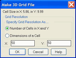
You have the option of setting the resolution of the grids.
There is also an option to report the fill volume in stages at an
elevation interval.
The Make 3D Grid File and Two Grid Surface Volumes
commands, used in combination, are an alternative to this command,
and in any situation in which there are cut and fill volumes
between the surfaces, that combination must be used to generate
accurate results.
Material density lbs/ft^3 (Enter for none): enter a material density in lbs per cubic
foot, or press Enter for none
Ignore Zero Elevations [<Yes>/No]?
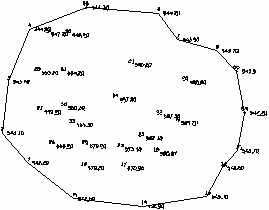
Select stockpile entities and perimeter.
Select objects: pick the objects that define the stockpile
and the 3D polyline perimeter
Select stockpile perimeter polyline:
Make Grid File dialog Set the resolution and then click
OK.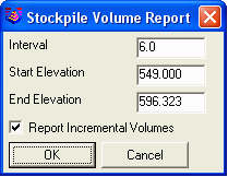 Sample volume report
|
|
Stockpile defined by points and a 3D polyline perimeter Window these objects to obtain the volume report |
Pulldown Menu Location: Surface >>
Stockpile/Pond/Pit Volumes
Keyboard Command: stockvol
Prerequisite: Data representing the stockpile surface and a
3D polyline representing the perimeter of the stockpile.