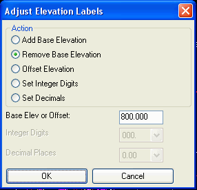
This command has several functions that allow you to modify spot
elevation labels.
The Remove Base
Elevation function removes the base elevation amount from
the labels. For instance, often elevations are abbreviated to save
space. If every elevation in a drawing is in the 500's instead of
labeling every elevation 523.5, 543.3, 537.2 sometimes you may wish
to have them displayed as simply 23.5, 43.3, 37.2. This command
allows you to adjust the labels by a given amount, such as 500, to
every label elevation. This does not affect the actual elevation of
entities in the drawing or in the associated surface model
file.
The Add Base Elevation
function is the reverse of Remove and applies when the labels are
missing the base elevation and you want to add this elevation into
the labels.
The Offset Elevation
function adds the specified offset amount to the elevation labels
and applies when elevation labels need to be adjusted by a fixed
vertical offset.
The Set Integer Digits
function sets the number of digits to the left of the decimal point
for the elevation labels.
The Set Decimals
function sets the number of digits to the right of the decimal
point for the elevation labels.
Pulldown Menu Location: 3D Data
Keyboard Command: adjust_elevation_labels
Prerequisite: Spot Elevation label text