 Prompts
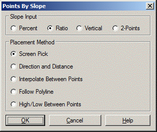
This command allows you to locate points by defining a slope from a reference elevation. There is an options dialog where you can define the slope format as percent or ratio. Enter the slope as positive for up, negative for down. You can also choose to enter elevation difference (vertical) instead of a slope. Or match the slope between two other points.
There are several difference methods for defining the X,Y
location for the points.
Screen Pick: Prompts for a
reference starting point and then you screen pick the new points to
create and enter the slope from the reference.
Direction and Distance:
First pick the starting point. If the picked starting point is at
zero elevation, the program will prompt for the reference
elevation. Next pick a point for the direction. Then enter the
slope and the horizontal distance.
Interpolate Between Points:
First pick the starting point. If the picked starting point is at
zero elevation, the program will prompt for the reference
elevation. Next pick the second reference point. Then enter the
slope and the number of points to create between the two reference
points. This number of points will be evenly interpolated between
the reference points.
Follow Polyline: This
method is similar to Screen Pick except that instead of using the
straight line distance between the reference and target points, you
pick a polyline to get the distance. The program gets the distance
by projecting the reference and target points onto the polyline and
then following the polyline between these projected positions.
High/Low Between Points:
With this method, you specify two reference points and two slopes.
On the line between these two reference points, the program locates
the point where the two slopes intersect.
Prompts
Slope ratio + for uphill - for
downhill, Start point should be 3D.
Slope Ratio (?:1) <2.0>: 1
Starting point ?
Pick point or point number: screen pick a point
Direction Point: screen
pick a point
Enter Hz Distance or [I]nterpolate
to Direction Point <I>: press Enter
Horizontal Dist: 214.94
Number of Points to Interpolate <2>: 5
Start Point Elevation: 0.0
End Point Elevation: 214.942
Difference in elevation: 214.942 Elevation add: 42.9884
Select/<Enter Point Elevation <42.99>>:
press Enter
Pulldown Menu Location: 3D Data > 3D Points
Keyboard Command: SLP
Prerequisite: None