This command places a structure on a flow polyline of the watershed schematic for TR-20 Hydrograph Development. The program prompts for elevation, discharge and storage data for the structure which is equivalent to the TR-20 STRUCT table data:
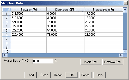
Water Elevation at T=0: Indicate the water-surface elevation at the structure at the beginning of the storm.
Insert Row: Inserts a row above the current row.
Remove Row: Removes the current row.
Load: Load a stage-discharge and/or stage-storage file into the table:
Graph: Description of Control.
Report: Produces a text report of the structure data.
Symbol size <4.0>:
Indicate the desired symbol size and press
Enter
Pick location on flow polyline for
structure: Pick a point on a flow
polyline and press Enter
Pulldown Menu Location: Watershed → TR-20 Routing
Keyboard Command: trstruct
Prerequisite: Flow polyline