This command draws polylines that represent flow lines. When drawing a network of flow lines, first draw the main branch. Then begin drawing the other flow lines from the top of flow and use the Join option to connect onto the main branch.
Draw Flow Polylines is the first command in a series that produce the watershed schematic for TR-20 Hydrograph Development. These flow polylines only represent the layout of the watershed and they do not need to be drawn to scale. After each flow polyline is drawn, the program prompts for the drainage area, curve number and time of concentration of the branch associated with that flow polyline. This data is used in the RUNOFF statement in TR-20. The flow polyline label shows the area over the curve number and time of concentration.
Text size <4.0>: Indicate the desired text size and press
Enter
Draw from highest to lowest elevation
(direction of flow).
Exit/Pick point: Graphically locate the upstream end of the flow
polyline
Undo/Exit/Join/Pick point: Graphically locate the next downstream location of the
flow polyline and press Enter when complete
Draw another flow polyline
[<Yes>/No]? Indicate if another
flow polyline should be drawn
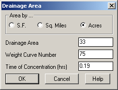
Area by: Indicate the unit of area for the Drainage Area control.
Drainage Area: Indicate the area that contributes to the hydrograph or click the Select button and pick a closed polyline.
Weight Curve Number: Indicate the weighted land use curve number that determines how much surface runoff will occur.
Time of Concentration: When using the TR-20 methodology, indicate the Time of Concentration (Tc) value.
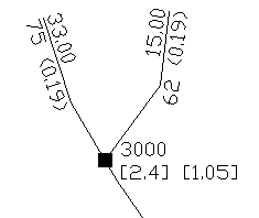
Main flow polyline with one branch and a reach
Pulldown Menu Location: Watershed → TR-20 Routing
Keyboard Command: trflow
Prerequisite: None