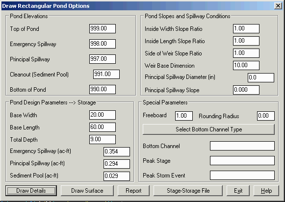
This program will draw rectangular ponds and calculate storage at any level in the pond corresponding to top of pond, emergency spillway, principal spillway and sediment (cleanout) level. Elevations can be "reverse-calculated" based on requested storage amounts. All calculations derive from input length-width and slope ratio values. Only one common ratio is used for the interior pond slopes (e.g. 1:1 or 2:1, etc.).
The Draw Details button
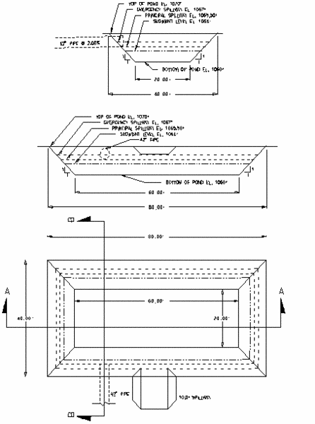
will output scaled and fully annotated plan view, section A-A and
section B-B drawings, complete with principal and emergency
spillways. For simplicity, the principal spillway is considered to
be a pipe spillway, and the emergency spillway is considered to be
a flat-bottom weir spillway. If the pond in question has only one
spillway, then the appropriate spillway elevation is entered in the
dialog box, and the other spillway option is left blank.
The Stage-Storage File button will produce a table of storage values as .CAP file which can be plotted using the file option within the Draw Stage-Storage routine and used in hydrograph routing routines. The Report function creates a report that is shown in the standard report viewer and includes pond dimensions, storage volumes and "Required Freeboard". The Draw Surface function will draw the pond into the drawing using the Design Bench Pond command. The program will prompt for the target surface model for the pond outslopes to tie into, the location and rotation for the rectangular pond, the top of dam width and the outslope slope ratios. The net effect of the Rectangular Pond Design routine is that you can calculate necessary pond storages, plot the pond detail drawings, write out and import the report summary and plot the pond stage-storage curve.
There are ways to use the routine in "shortcut" form to draw ponds. Simply by completing 3 dialog entries (base width, base length and total depth) the user can draw the plan view, section A-A and section B-B. This is why the Pond Elevation items are considered "optional". The programs can also be used as a pond storage calculator. Any of the Pond Elevation options (excepting peak stage), when completed will lead to recalculated storage values. Storage values can likewise be altered and will lead to recalculated elevations. The act of pressing enter inside a dialog box activates the calculation process. If there is no need to plot the pond detail drawings, the cancel "button" in the dialog can be selected following calculations.
The program begins by presenting the dialog. One effective way to fill out the dialog boxes is to pick the upper left box and work down and through the options by pressing the tab key after each entry. If all items are filled out as shown, the following prompts will appear:
Enter Scale Factor for Pond Drawing(s) <1>: press EnterIf no Section A-A or Section B-B identifier lines are drawn, no section A-A or Section B-B details will be drawn. Thus if you want Section A-A only, say "y" to Draw Section A-A Horizontal but "n" or Enter to Draw Section B-B Vertical. If you entered only length, width and depth in the original dialog, the resultant prompting would be:
Enter Scale Factor for Pond Drawing(s) <1>:
press Enter
Draw Plan View? (<y>/n): press Enter
Pick Lower Left Corner:
Draw Section A-A Horizontal
(y/<n>): y
Pick Left Location of Section A-A:
Pick Right Location of Section A-A:
Draw Section B-B Vertical (y/<n>): y
Pick One Side of Section B-B:
Pick Other End of Section B-B:
Pick Upper Left Corner of Section A-A:
Pick Upper Left Corner of
Section B-B:
|
| Plots produced by the entries in the preceding dialog |
Keep in mind that the scale factor, if other than 1, will enlarge or reduce the size of the detail drawings to suit the users needs, yet will annotate dimensions correctly in all cases.
The imported text based on the output ASCII file POND.TXT (located in \SCADXML\WORK by default) would appear as follows:
Top of Pond Elevation: 1070.00 feet Peak Stage
(25th year-24 hour Storm Event): 1069.45 feet Includes 1.00
feet of Freeboard Emergency Spillway Elevation:
1067.00 Emergency Spillway Bottom Width: 10.00
Principal Spillway Invert Elevation: 1065.50 feet
Principal Spillway Diameter: 42.00 in.
Principal Spillway Slope: 2.00 % Sediment Pool (Cleanout)
Elevation: 1064.00 feet
Bottom of Pond Elevation: 1060.00 feet
Storage Volume at Emergency Spillway: 0.2990
ac.ft.
Storage Volume at Principal Spillway: 0.2150
ac.ft.
Storage Volume at Sediment Pool: 0.1430
ac.ft.
The routines are fully metric and will substitute meters and cubic meters appropriately for feet and acre-feet. Pipe sizes, however, will default to diameters in inches.
Pulldown Menu Location: Structure in Hydrology
Keyboard Command: rpond
Prerequisite: None