|
| Spillway added to valley pond |
This command creates a spillway with 3D polylines in the drawing. The program uses a surface model of the area for the spillway, a spillway centerline and spillway dimensions (width, elevation, etc.). The surface model of the area can be defined by contour polylines, points and 3D polylines or can be created by the Design Bench or Valley Pond commands. The spillway dimensions can be calculated by the Design Channel commands to meet the desired discharge. The amount of cut required to make the spillway is calculated and reported.
Source of surface model (File/<Screen>)? press
Enter Use the File option to select a .grd file.
Pick Lower Left limit of surface area: pick lower
left
Pick Upper Right limit of surface area: pick upper
right Be sure to pick these limits well beyond the area of the
spillway centerline in order to make room for the outslopes.
Make GRiD File Dialog
After selecting the limits of the disturbed area the program will
generate a 3D grid that represents the surface. Specify the grid
resolution desired and select OK.
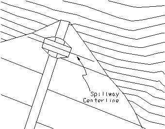
Pick the spillway centerline: select polyline that crosses
the dam
Pick a point within the pond: pick a point The program needs to know
which end of the spillway centerline is within the pond.
Enter slopes as percent grade or slope ratio
(Percent/<Ratio>)? press Enter
Enter the side slope ratio <1.0>: press
Enter
Enter the flow slope ratio <100.0>: press
Enter
Range of existing elevations along spillway centerline.
Enter spillway elevation <1476.5>: 1475.0 This is the entrance elevation
of the spillway
Enter the spillway width <10.0>: press
Enter
Spillway Report:
Spillway inlet elevation:
1445.0000
Spillway outlet elevation: 1445.0000
Spillway width: 10.0000
Side slope percent grade: 100.00, slope ratio: 1.00
Flow slope percent grade: 1.00, slope ratio: 100.00
Spillway EarthWork Volumes
Total cut: 55.593 C.Y., 1501.00150 C.F.
|
|
| Spillway added to valley pond |
Pulldown Menu Location: Structure in Hydrology
Keyboard Command: spill
Prerequisite: Surface entities that model the pond