

For each strata in the drillholes, this routine can generate isopach maps, or isolines of the strata thickness, bottom elevation, and attributes such as moisture, sulfur, and BTU. An isopach map is essentially a contour map of the specified strata values.
At the start, there is an option to isopach from either from
Grid File or Drillholes From Screen. The file option will contour
from stored grid files. In the screen option, the program reads the
strata data from the selected drillholes and builds strata models
on-the-fly while applying pinch out and conformance as set in
Configure, Mining. With the screen method, there is an option to
draw labels next to the drillholes for the data values used for
modeling which is helpful to visualize the source data. Then the
program shows a list of strata. After selecting a strata to
process, the program cycles through all the possible strata values.
When one of these values is chosen, the contour options dialog box
is activated which allows the contouring parameters for the isopach
map to be set.
Smooth Contours Setup: The Low to High slider bar controls the amount of smoothing. This smoothing method is based on the Bezier method. The Apply Outlier Reduction Filter option will remove spikes in the contour polylines that don't follow the general trend of the contour. The Reduce Before Smoothing option applies the Reduce Vertices function on the contour polylines before applying the Bezier smoothing. By reducing before smoothing, the contours will have more freedom to smooth since the Bezier method holds all original polyline vertices and the reduce will result in fewer vertices to hold. The Offset Distance is the maximum distance the contour is allowed to shift when removing vertices during reduce. Smoothing Sub-Division will internally subdivide the grid cells with a quadratic smoothing algorithm to help create smoother contours.
The Hatch Zones option will fill in the area between contours with a hatch pattern and color for that zone. For example, hatch zones will create a thickness isopach map with the 0-2 area in blue, 2-4 in green and 4-6 in red etc. The Polyline topology option will create closed polylines of each contour zone. This can be used for GIS type applications in other modules.
The Draw Drillhole Labels option draws text next to each drillhole with the value that was used for contouring. After creating the contours with this routine, the contours can be labeled and highlighted with the contour embellishment commands in the Contour drop-down of the Contour-DTM module. The first window determines the source of the isopach and the modeling process if from drillholes. Use Triangulation Subdivision will be applied to the modeling with triangulation. This process is documented in the Make Grid command. Create Composite Contours will allow for multiple strata to be selected at once, to create a "total coal" thickness isopach for example.
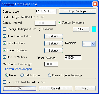
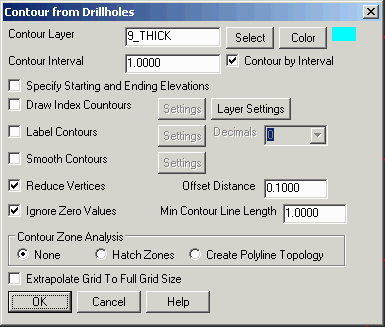
There are two different dialogs, depending if you are contouring
from drillholes or a grid. They are both shown below.


Shown above is an Isopach map with legend using hatch zones. Below is a typical isopach without hatching.
Pulldown Menu Location:
StrataCalc
Keyboard Command: chiso
Prerequisite: Drillholes