Quick Fence
Quick Fence is very similar to Quick Profile, in that an instant
profile appears at the bottom of the screen, displaying the
surfaces. This fence alignment can be set by picking points,
selecting a centerline file, or selecting a polyline from the
screen. A triangle appears in the plan view as the cross hairs are
moved along the fence diagram below. This displays where along the
fence line the cross hairs are. The slope of the surface, the
station and elevation appear dynamically below the buttons. The
Adjust Alignment function allows you to drag a horizontal alignment
point and update the fence diagram in real-time for quick and
efficient grid model verification.
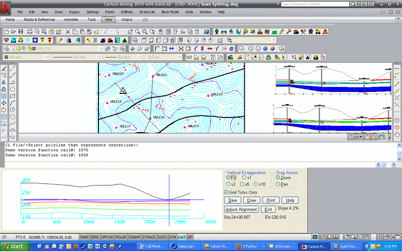
- Vertical
Exaggeration: This usually starts at "Fit" to size the fence
diagram into the window. The other exaggerators, x1, x2, x5 and x10
can be selected to exaggerate it vertically.
- Drag Action: The
fence image can be modified with either the zoom or pan
actions.
- Grid Ticks Only:
Turning off this box will extend the elevation and stationing tick
marks all the way across the fence diagram.
- Save: This option will save the surface as a *.PRO
profile
- Draw: Selecting this will put the fence diagram in
the drawing with the Draw Profile command. The result will be
similar to Draw Profile with multiple surfaces.
- Print: This will print the fence diagram to a PDF
file.
- Adjust Alignment: This option allows for the fence line on
screen to be moved. If the center of the polyline is selected, then
the fence line can be moved in any direction, and the seams will
dynamically update as the polyline is moved around. If one of the
endpoints is selected, then the fence line can be rotated around
the other endpoint, or extended to another length. This is a great
tool to do a quick check of the geological grids with real-time
graphic feedback on the model status.
Prompts
Select the Geologic Model File (*.PRE)
Pick starting point (CL-Centerline,P-Polyline): p if the polyline is drawn on
screen
Polyline should have been drawn in direction of increasing
stations.
CL File/<Select polyline that represents centerline>:
select the polyline
Drop-Down Menu Location: under StrataCalc
Keyboard Command: qfence