
This command assigns strata names to identify polylines as inclusion or exclusion areas for the strata. Strata limits are used to model discontinuities such as glacier washout or volcanic strata. Strata that gradually trend to pinch out should not use strata limits. The pinch out should be modeled using just the drillholes. When assigning the names for strata in the Geologic Model file, be sure they are spelled exactly the same here, so they are applied correctly. Also, when using Limit Polylines with bed names in the drillholes, be sure to add the _TOP, _KEY, _PARTING, OR _BOTTOM to make sure the limits are applied to each bed interval.
Strata limit polylines are used in the Stratacalc routines to
indicate where the strata exists. The inclusion and exclusion
polylines are used for trimming the contours in Strata Isopach Maps
and used to limit volumes in routines like Surface Mine Reserves.
Also in areas outside the strata limits, the strata thickness is
set to zero and 10000 is added to the strata elevation. This forces
the strata up to clip out to the strata above. Also drillholes that
are outside the strata limits are ignored for processing that
strata. There is a choice to assign all strata names to the limit
lines, or Specific strata. If Specific is chosen, then the
following dialog appears.
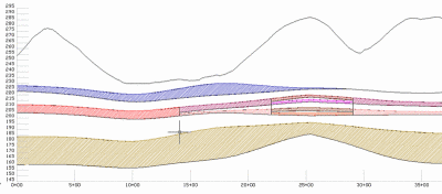
When drawing a Fence Diagram and using Limit Polylines, the strata cutoff occurs exactly at limit the polylines. Shown here is an example of a Fence Diagram, plotted with the plan view for verification. Notice how the limit lines crop the seams in section view precisely at the limit lines. The plan view was placed on top of the fence diagram just with basic AutoCAD drafting tools. Dashed polylines were then drawn with ortho on to illustrate the crops honoring the limit lines exactly. For all StrataCalc routines that use limit polylines, there is a command line message to report when limit polylines are applied.

Another use of Limit Lines is to control the transition from a full seam to where it splits. Limit lines must be drawn for one or both instances. The full seam and the two split seams can both appear in the Geologic Model file for volumes and Fence diagram. An example Geologic Model is shown here. Notice the C2_KEY splits into C2L_KEY and C2U_KEY. They also split. All of these can exist in the Geologic Model, as long as there are limit lines on screen to control where they appear.

The result is a Fence Diagram as shown here, where the limit lines control where the full seam, and its splits appear.
Enter strata name to apply (<All>/Name)? UB
for strata UB
Select Inclusion perimeter polylines.
Select objects: pick a closed polyline
Select Exclusion perimeter polylines.
Select objects: press Enter
Pulldown Menu Location: StrataCalc
Keyboard Command: minelmt