This command reports object properties to you as you move the cursor over an entity. You can simply move the pointer over an entity and the selected property will be displayed either in a pop-up window next to the pointer and/or on the status bar, depending on the selected option. Drawing Inspector is a transparent command that can run while other commands are running. Once Drawing Inspector is started, it will stay active even while running other commands until you turn it off. To turn off Drawing Inspector, run the command again to toggle it off by pick Drawing Inspector from the Inquiry pull-down menu or from the toolbar or by typing the command name, or right-click and choose Turn off Drawing Inspector. The options for this command are set in the menu that pops up by clicking the right mouse button. The available properties are: Layer Name, Elevation, Azimuth-Distance, Bearing-Distance, Point Data, Text Data, Curve Data, 3D Face Data, Polyline Data and Polyline Blips.
In the Drawing Inspector menu, you can choose one or more properties to display.
Display Layer Name: displays the
layer name of the entity.
Display Entity Type: displays the type of the entity
(ie. TEXT or POLYLINE).
Display Elevation: displays the elevation of the
entity.
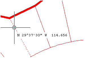
Display Azimuth-Distance: displays the azimuth and
distance of a line.
Display Bearing-Distance: displays the bearing and
distance of a line.
Display Point Data: displays the coordinate data of
point.
Display Text Data: displays the contents of text.
Display Curve Data: displays the radius, arc length,
chord length and delta angle of a curve.
Display Polyline Data: displays the end point
elevations, horizontal distance, slope distance and slope
ratios.
Display 3D Face Data: displays the Z elevations at
the face corners.
Display Polyline Blips: displays temporary
blip plus marks at the vertice locations of polylines.
Display Polyline Direction: displays temporary
arrows to show the direction of polylines.
Display Surface Elevation: prompts for a TIN or grid surface
file to load and displays the surface elevation at the current
cursor location.
In the Drawing Inspector menu, you can also choose how the property information is reported.
Enable Highlighting: Allows you to highlight the
object that the Drawing
Inspector is reporting.
Enable Tag Display: Enables you to view the information next
to the cursor on the screen.
Show Data On Status Bar: Enables you to view the information
on the status bar, in the lower corner of the screen.
Use Default Cursor: When enabled, only the drawing cursor
shows. When disabled, the mouse pointer is also shown.
Report In High Precision: When enabled, displays 8 decimals
on distance and 4 decimal seconds on angles.
|
|
|
Example of Drawing Inspector reporting |
Pulldown Menu Location: Inquiry
Keyboard Command: inspector
Prerequisite: None