The Export Google Earth File allows you to produce a KML (Keyhole Markup Language or alternatively a KMZ) file of points, polylines, text, solids, images, lines and arcs for rendering in other mapping and GIS applications such as Google Earth and Google Maps. Throughout this discussion, KML will be used to also describe KMZ files unless explicitly noted.
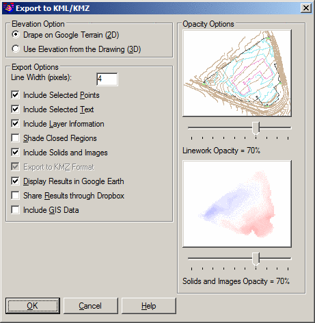
Drape on Google Terrain (2D): When this option is selected, entities written to the KML file will have an Altitude setting of "Clamped to ground."
Use Elevation from the Drawing (3D): When this option is selected, entities written to the KML file will have an Altitude setting of "Absolute."
Line Width (pixels): Indicate how wide selected linework should be when viewed in Google Earth. The higher the value, the thicker the line.
Include Selected Points: When enabled, this option exports selected Carlson point information to the KML <Placemark><Point>...</Point></Placemark> tag structure. For the Google placemark, you can choose between using the point number, elevation or description.
Include Selected Text: When enabled, this option exports selected Text and MText entities to the KML <Placemark><Point>...</Point></Placemark> tag structure.
Include Layer Information: When enabled, this option organizes exported information based on the layer of each entity, with each CAD layer becoming a KML <Folder>...</Folder> entry with the color of the group taking the general color of the CAD layer.
Shade Closed Regions: When enabled, all closed polyline regions (e.g. building pads, ponds, etc) will be fill-shaded.
Include Solids and Images: When enabled, Solid entities and Images are included in the KML as <Placemark><Polygon>...</Polygon></Placemark> and/or <GroundOverlay>...</GroundOverlay> tags, respectively.
Export to KMZ Format: When enabled, the KML file is written to the more compact (zipped) KMZ version of the standard KML file format.
Display Results in Google Earth: When enabled, the results of the KML are passed to and automatically opened with Google Earth. To setup for running Google Earth Pro, go to Windows Start > Default Programs > Associate File Type With Program and assign KML and KMZ file types to Google Earth Pro.
Share Results through Dropbox: When enabled, the results of the KML are passed to a personal DropBox account.
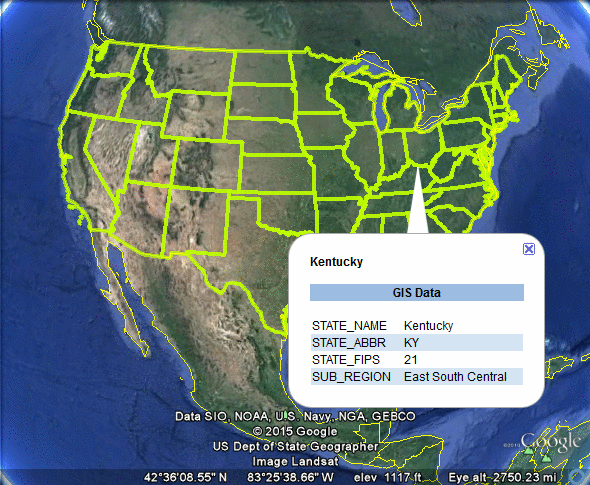
Include GIS Data: When enabled, GIS attribute data associated with selected entities will be populated into the KML file. GIS attribute data can be imported via the Import SHP File command (see the Sample Esri Data note below) or manually assigned with the Input-Edit GIS Data command or the Set Google Tags command. Upon specifying the KML file to output, the Quick View Settings dialog box of the GIS Inspector command may display:
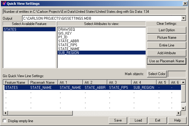
Upon exiting from the dialog box, available GIS Data on a per-entity basis will be populated into the KML file:
Linework Opacity: Use the horizontal slider control to indicate the desired level of opaqueness that should be applied to linework entities. A lower opacity results in increased entity transparency and is helpful for viewing underlying map data found in applications such as Google Earth.
Solids and Images Opacity: Use the horizontal slider control to indicate the desired level of opaqueness that should be applied to Solids and Image entities. A lower opacity results in increased entity transparency and is helpful for viewing underlying map data found in applications such as Google Earth.
Select points, polylines, text, solids,
images, lines and arcs to write.
FILter/<Select entities>: Select
the desired entities and press Enter when
complete.
Pulldown Menu Location(s): File > Export
Keyboard Command: kmlwrite
Prerequisite: Points, lines or polylines in the drawing with
an established projection zone through Drawing
Setup.