This command creates a SHP file from the selected entities in
the drawing. After selecting entities to be converted, a dialog
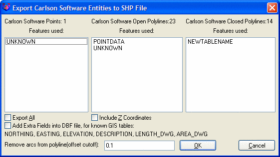
shows the number of Points, Polylines (Arcs) and Closed Polylines
(Polygons) found in the drawing selection set. Those Points, Arcs
and Polygons with database information linked are displayed with
their database table names. Any Points, Arcs and Polygons without
linked database information display as unknown. The Coordinate
System setting chooses between creating a SHP file using the
northings/eastings from the drawing or using lat/lon by converting
the drawing coordinates to lat/lon with the projection parameters
from Drawing Setup.
Highlight the Point, Arc and Polygon tables to output or selects Export All to select all entities including the UNKOWN entities to export into SHP files. The Export SHP File commands outputs all entities selected into SHP files with the same name as their table name into a subdirectory selected. Also Points can be stored in the ESRI Arcview database as 3D X, Y and Z coordinates when Include Z Coordinates is toggled on. SHP files do not have arc entities. So the export routine will convert arcs and polyline arcs into a series of small chords segments. The Offset Cutoff field sets the maximum horizontal shift allowed between the original arc and the chord segments.
These SHP files can be imported into ESRI's Arcview product. Database GIS links in Carlson are converted to SHP files by storing the GIS database information into DBF files for ESRI's Arcview product to read and link to.
Specify Name for SHP File
dialog select .SHP file
name
Select
objects select
entities
Export Carlson
Entities to SHP File dialog choose settings, click OK
Pulldown Menu Location: GIS Data
Keyboard Command:
export_shp
Prerequisite: None