Define GIS Features
This command creates the Feature/Attribute data structure,
template database or schema, for GIS functionality. The
structure is stored in a Carlson Features File with a GIS file
extension.
A feature, such as a manhole, can have multiple attributes, such
as Number of rungs, Type of material, Number of inlets, etc.
Features can be organized into Categories: Utilities, Roads,
Properties. The Category designation is an arbitrary way of
organizing the features. Features and attributes can be
imported from:
- Carlson GIS Features file (.GIS)
- Carlson Field to Finish file (.FCL)
- Esri MSC data contained within the drawing (.DWG)
- Carlson Template Database file (.MDB)
- Trimble Features file (.FXL or .FCL)
- SurvCE Features file (.VTT)
- TDS Features file (.FEA)
- Comma Separated Values (.CSV)
- Carlson Coordinate File (.CRDB)
- Esri File GeoDatabase (.GDB)
Features and attributes can of course also be defined "from
scratch" in the Define GIS Features dialog box. The workflow is
outlined below.
- Set the GIS file name which will contain the features and
attributes structure. Use the File menu to create a new
(.GIS) file or open an existing one for editing. Please note that
the system will only process correctly if a FCL and a GIS file both
have the exact same file name
- Set up one or more Category Names, using the Category
menu. GIS feature codes can be categorized (e.g. STRUCTURES,
UTILITIES, ROAD FEATURES, etc.). At least one category must be
created.
- Define Features, using the Feature menu. To edit a
feature, double-click on the feature name.g. A category such as
UTILITIES might have features such as manholes, light poles, fire
hydrants, water valves, etc.
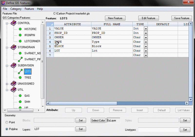
- Define the attributes for the Feature. Each attribute
has:
- a) a Name
b) a Full Name, or Prompt
c) a Type - Integer, Character or Real
d) a system Default Value. Press the Default button to add a system
variable from a list. For example, press Default > Elevation.
The system will add $EQN=$LAT, a system variable that will insert
the current latitude from the point measurement
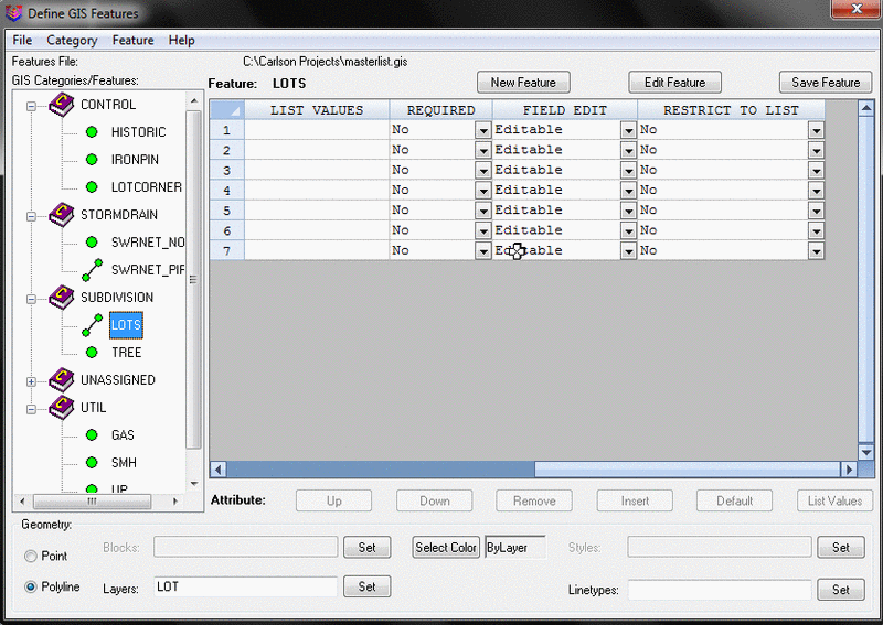
e) optionally, a List of values to pick from. Use the List
Values button or type in each value followed by Enter within the
field required, to build a list. The list will as a pick list when
the attribute screen is shown.
f) whether the attribute is required
g) whether the attribute Value can be field Edited, appears as Read
Only, or is Hidden
h) whether the value used is restricted to the list
The order of attributes appearing on the data-entry screen is
controlled by the Up and Down buttons.
Geometry
Settings
At the bottom of the
dialog box the user can specify the geometry settings for each
feature. Each feature can be defined as a polyline or point. Each
feature can also have a layer, block text style and line type
defined. Please note that GIS features can only be defined on
polylines and not lines.
Pulldown Menu Location: GIS Data
Keyboard Command: def_template
Prerequisite: None