Data Capture Block Attributes
This command automates data transfer from block attributes to a
database table. Many drawings are warehouses of information. The
Data Capture Block Attributes command applies to drawings that
contain blocks with attribute values.
The command starts by prompting to select one sample of the block
to capture. The program reads the attribute names from this sample
block. This example uses Carlson point blocks that have attributes
for point number, elevation and description.
Next, there is a dialog for specifying the attributes to capture
and their order. Each sample attribute is available to capture by
moving these fields to the block attribute list. There is an option
to create a new block out of the selected attribute by turning on
the Create New Blocks option. In the New Block Name and Layer Names
fields, you can specify the name and layer for the blocks. The
Delete Objects option will erase the source block entities. In the
Block Attribute Properties spreadsheet, you can set the block tags,
prompt, default and layer for each attribute.
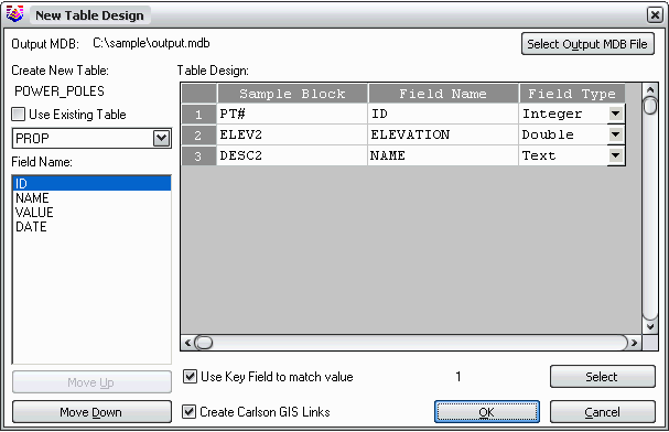
The second dialog setups up the database table to create from the
block data. The destination database is set with the Select Output
MDB File button. You can either create a new table in the database
or select an existing table. Under Table Design, you can set the
Field Name and Field Type for each attribute when a new table is
being created. When adding to an existing table, the Field Name and
Field Type are read from the existing table. For with an existing
table, the Field Name list in the lower left will show the field
names from the existing table, and the order of these fields should
be set to match the order of corresponding the text fields. The Use
Key Field To Match Value option will use the selected record as the
key field for the database table. The key field must have unique
values for each record in the table. To set the key field,
highlight the record row # in the spreadsheet and then pick the
Select button. The Create Carlson GIS Links option will link the
database table with the drawing entity for each record.
After the dialogs, there is a command line prompt to select the
blocks to import. Only blocks that match the sample block names
will be processed.
Prompts
Select sample block to
capture: select a
block
Processing entities...Please
wait...
Select entities to process
[Select/<All>]: All
Created 2 GIS
Links.
Done
Pulldown Menu Location: GIS
Data > Data Capture
Keyboard Command:
cgis_getblockattr
Prerequisite: Blocks with
attributes