Visual Map Check
This routine allows you to graphically pick the Call Text (Bearings
and Distance) from a drawing and perform a Map Check Closure.
Prompts
First you will be asked: Pick
Point of Beginning: You can enter the beginning point
number, or graphically pick the point on the screen.
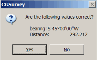
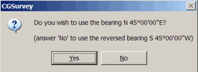
Next: Pick Bearing Text for Leg 1
(ask Reverse is ON) [Off/Done]<Done>: Graphically pick
the text with the Bearing. If “ask Reverse” is turned ON, you will
be allowed to reverse the direction of the bearing after it is
selected:
 Next: Pick Distance Text for Leg 1:
Graphically pick the text with the distance. You will
see:
Next: Pick Distance Text for Leg 1:
Graphically pick the text with the distance. You will
see:
If you select YES, you will go to
the next leg. If you select NO: you will be asked to pick
the Bearing and distance for Leg 1 again.
After selecting all the
Calls: press ENTER for DONE. You will have the
option:
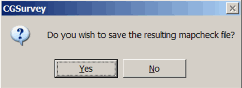 If you select YES, the information: you
selected will be placed in a Map Check File. You will be asked to
select the CGM file.
If you select YES, the information: you
selected will be placed in a Map Check File. You will be asked to
select the CGM file.
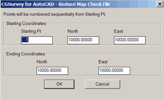 Next: Enter the starting and ending
coordinates for the traverse.
Next: Enter the starting and ending
coordinates for the traverse.
The map data will then be reduced and the coordinates stored in the
coordinate file. Overwrite protection is in place in case the
points already exist in the coordinate file. If a point already
exists in the coordinate file you will have the following
options:
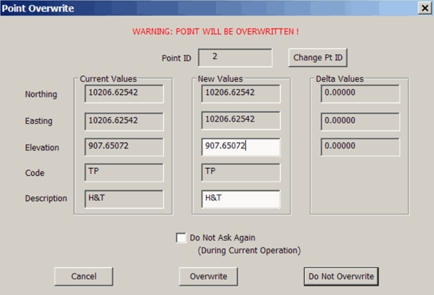 CANCEL: will terminate the process of
storing coordinates.
CANCEL: will terminate the process of
storing coordinates.
OVERWRITE: will overwrite
the existing point.
DO NO OVERWRITE: skip to
the next point. If you have the “Do Not Ask Again” box checked,
OVERWRTE will overwrite all points without asking, DO NOT
OVERWRITE: will only write
NEW points to the coordinate file.
Below is a sample Report:
Correct Ending Coordinates, North: 10000.00000 East:
10000.00000
Ending Coordinates, North: 9586.74896 East: 9586.74832
Error, N: -413.25104 E: -413.25168 Total: 584.42568 Brg: N
45°00'00"E
Distance Traversed: 1492.10700 Closure: 3
Adjusted by Least Squares
Bearing
Distance
Northing
Easting
Elevation
Point ID
10000.00000
10000.00000 900.00000
1
S 58°19'27"W 146.64772
9922.99352
9875.19793
2
N 05°19'46"W 299.65818
10221.35627
9847.36450
3
N 73°17'06"W 156.24457
10266.29428
9697.72179
4
S 04°35'43"E 226.90862
10040.11507
9715.90113
5
S 64°19'20"E 371.14929
9879.29253
10050.39763 900.00000
1
Sq. Feet: 814183.13568 Acres: 18.69107
Pulldown menu Location:
CGTrav
Keyboard Command:VM,
cg_visual_mapcheck
Prerequisite: Call Text
must be displayed to select